

• Smith River Falls is a popular site offering camping, hiking, fishing, and swimming opportunities
• The cascading waterfall drops into a deep pool between the rock ledges
![]()
![]()
![]()
![]()
![]()
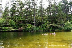
A popular summer destination Smith River Falls Recreation Site is located 27 miles east of the coastal town of Reedsport. Surrounded by old-growth alders and fir trees, this site features excellent swimming and rock jumping pools, as well as flat rock ledges for relaxing and sunbathing. The beautiful cascading waterfall is formed by the 90-mile Smith River that flows from the north of Drain, through mountains of the Coast Range, and, finally, empties into Umpqua River, roughly 7 miles from the Pacific Ocean.
Like other coastal creeks and rivers, the Smith River warms up quickly and at the peak of a summer season, the water is comfortable for taking a refreshing dip.
The route from Reedsport via Smith River Road that runs along the river is the best way to get to this site. If you drive from Eugene, a part of the route goes via poorly maintained mountain-forest roads through the wild areas; it takes over 2 hours for a 60-mile trip. Also, it is easy to get wrong directions because the roads are not clearly marked.
Smith River Falls Recreation Site is located in the river rocky canyon, right off Smith River Road. Park your car along the road and go downhill.
Two very steep trails lead down to the river bench just below Smith River Falls. An easier path to the top of the waterfall can be found on the left of the parking area.


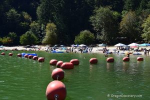
The 10-foot cascading waterfall drops into a deep rectangular pool which is used for swimming and cliff jumping. A fish ladder next to the waterfall was built in 1971 as a part of the Fish Restoration and Enhancement Program.
Other excellent deep and shallow pools for swimming and wading can be found above and below the waterfall. A rope swing is available in the big dip pool below the waterfall. Large flat and rounded rock ledges with interesting potholes serve as a great platform for relaxing between your swimming or jumping activities.
Along with swimming, Smith River Falls Recreation Area, operated by BLM, offers camping, fishing, and hiking opportunities. A small campground for 10 sites with picnic tables and fire rings is located just above the waterfall. The campsites are available on a first-come, first-served basis.
This is a beautiful area where you could easily spend an entire day. Please respect the place and leave no trace.
Cautions: Cliff jumping and slippery rocks are associated with risks, please use caution and make safe decisions.
Video
Camping & Lodging
The campground is situated above the falls and open from Memorial Day to September 30. The scenic area surrounded by old-growth forest at the river has free 10 tent sites with picnic tables and fire rings. There us a boat launch. The campground is available on a first-come, first-served basis.
Lodging is available in Reedsport, 27 miles away.
Affordable vacation rentals for short and long term stay in the Reedsport area.
Smith River Falls | Facts
Open: Day-use area - year-round; Campground - from Memorial Day to September 30
Managed by: BLM
Amenities: Toilet, campground, no drinking water
Activities: Swimming, cliff jumping, rope swinging, fishing, hiking
Distance from the parking: Short
Road access: Any passenger vehicle
Day-use fees: None
Elevation: 200 ft (61 m)
Smith River Falls is located:
- 27 miles northeast of Reedsport
- 58 miles southwest of Eugene
- 70 miles northwest of Roseburg.
Swimming hole rating: 4 out of 5
Body of Water: River
Water quality: Good to fair
Current: Light
Depth: Deep and shallow
Beach: Rock ledges
Water T° (summer): Cool to warm
Adventures Nearby


Directions to Smith River Falls
From Reedsport,
- Drive north on Highway 101 to Smith River Road
- Turn right (east) onto Smith River Road and travel 26.5 miles to the destination.
If you're traveling east to west, Google Navigation can direct you via Highway 38 and then poorly maintained BLM forest roads. We don't recommend using this option. Use the directions provided above.
Phone: 541-756-0100