

• Paulina Lake Hot Springs is located at the north edge of the Paulina Lake
• Features five or more man-made pools
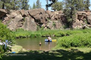
Paulina Lake Hot Springs consist of natural geothermal vents that rise from the lakebed of Paulina Lake. Many of the hot springs are submerged in the lake, where they mix with colder water.
However, a few springs along the northern shoreline can be accessed on foot or by boat.
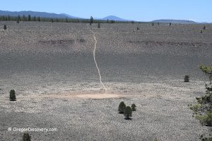
Paulina Lake is one of two alpine lakes located within the Newberry Caldera, one of the most active geothermal areas in the United States.
The caldera was formed hundreds of thousands of years ago when a volcanic eruption caused the collapse of a large magma chamber. The second lake, East Lake, is about 2 miles east of Paulina Lake and has its own hot springs known as East Lake Hot Springs.
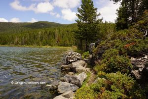
Along Paulina Lake’s shoreline, visitors can find several natural soaking areas near Hot Springs Beach, a gravel area about a quarter-mile long. Some shallow pools form naturally along the shore, and visitors shape others over time. Hot water rises through volcanic sand, gravel, and rocks.

In spring and early summer, higher water levels often submerge the hot springs along the beach. As water levels drop later in the season, more soaking areas become exposed.
The best time to visit is typically late spring through mid-summer, when water levels are suitable for soaking.
Water temperatures vary throughout the year, generally ranging from about 90°F to 115°F. The geothermal source can be much hotter underground. The water has little to no sulfur smell, unlike many hot spring areas.
According to U.S. Forest Service, this is a sensitive riparian area, so visitors must use existing soaking spots and are not allowed to dig new pools.
Camping and fires are also prohibited on Hot Springs Beach.

Hiking to Paulina Lake Hot Springs
Hot Springs Spur Trail
The shortest route to the hot springs is a two-mile trail along the east shore of Paulina Lake, starting from the far end of Little Crater Campground.
Paulina Lake Trail
The 7.5-mile loop trail around Paulina Lake begins near Paulina Lake Campground.
The trail offers scenic views of the lake, nearby volcanic features including the Big Obsidian Flow, and areas of geothermal activity.
Video
Paulina Lake Hot Springs Camping and Lodging
Camping is not allowed directly at the hot springs. However, nearby options include Paulina Lake Campground and Little Crater Campground, both offering tent and RV sites, picnic tables, restrooms, and drinking water.
During summer, reservations are often required and can be made through Recreation.gov.
For more comfortable lodging, Paulina Lake Lodge offers cabins, meals, and boat rentals. Additional hotels and accommodations are available in Bend, a nearby city.

Paulina Lake Hot Springs | Facts
Best time: May through mid-October from sunrise to sunset
Managed by: U.S. Forest Service
Development: Wild
Amenities: None
Activities: Soaking, hiking, boating, fishing
Clothing: Swimsuits would be handy
Distance from the parking: 2 miles
Road Access: Any vehicle to the trailhead
Day-use fees: Yes, or Recreation Passes
Elevation: 6,350 ft (1,935 m)
Paulina Lake Hot Springs is located:
- 19 miles east of La Pine
- 39 miles southeast of Bend
- 200 miles southeast of Portland.
Water temperature: 90°F (32°C) to 115°F (46°C)
Water acidity level: Acidic (pH=6.82)
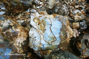
Type of the springs: Sodium Silicate
Chemical used: None
Silica - 205 Mg/L
Sodium - 140 Mg/L
Magnesium - 60 Mg/L
Calcium - 56 Mg/L
Potassium - 17 Mg/L
Chloride - 6 Mg/L
Fluoride - 0.57 Mg/L
Adventures Nearby
Directions to Paulina Lake Hot Springs
From Bend,
- Travel approximately 23 miles south onto US 97 to Paulina East Lake Road
- Turn left onto Paulina East Road and drive 14 miles east to the sign Little Crater Campground
- Turn left onto Little Crater Campground Road and travel to the end of the road (the Paulina Lake Hot Springs Trailhead).
From the trailhead at Little Crater Campground, hike 2.3 miles on the Paulina Lakeshore Loop Trail.
GPS (Hot Springs): N 43°43.920' W 121°15.102' | 43.732, -121.2517
GPS (Trailhead): N 43°43.084' W 121°14.485' | 43.7181, -121.2414
Menlo Park. "Chemical and Isotopic Data for Water from Thermal Wells and Springs of Oregon". United States Department of the Interior. Geological Survey. 1980.
US Forest Service
There are no hot springs already made. You need to mention that ou have to walk 2 miles from your parked car then you have to dog your own hole and wait for it to fill up.