Fort Stevens: Active Military Installation
 Fort Stevens was an active military installation until 1947 and the only one continental U.S. military base to be attacked by a foreign army since the War of 1812.
Today the 4,300-acre area around Fort Stevens is a state park offering numerous outdoor activities including camping, hiking, fishing, boating, swimming, and exploring Oregon history.
Fort Stevens State Park - Outdoor Adventures from Bunkers to Beaches
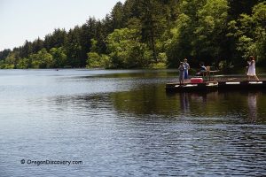
Coffenbury Lake
 Coffenbury Lake is a 56-acre typical coastal lake, containing water of rainfalls and snow that was trapped between sandy dunes decades ago.
The lake is a perfect place for swimming, boating, and fishing. Anglers can catch largemouth bass, bluegill, black crappie, brown bullhead, and yellow perch. The lake is also stocked with adult hatchery steelhead and legal-size rainbow trout.There are fishing docks, boat ramps, sandy beaches, and picnic sites.
Coffenbury Lake - A Tranquil Retreat in Fort Stevens State Park