

• Steamboat Falls is a block-type waterfall in the Umpqua National Forest
• This is a great summer destination for sunbathing and swimming
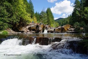
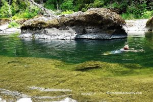
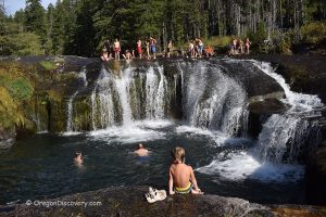
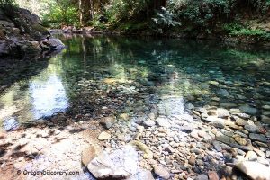
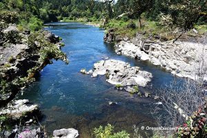
Steamboat Falls is a block-type waterfall that gradually cascades over stone slabs into a deep canyon with emerald-green water. It is at its most powerful during the wet season, though still impressive in summer.
Located in the Umpqua National Forest, Steamboat Falls is a great destination for hiking, mountain biking, boating, camping, swimming, and wildlife watching.
From May to July, visitors can also watch steelhead trout leap to the top of the 25-foot waterfall.
A fish ladder runs alongside the waterfall and partially drains Steamboat Creek. Fishing is prohibited in the creek and all its tributaries, as these waters provide essential spawning habitat for the North Umpqua River steelhead run.

Things to Do at Steamboat Falls
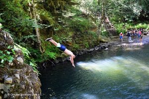
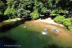
Swimming and Sunbathing
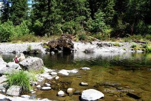
The flat rock outcroppings at the top of the waterfall are perfect for sunbathing. Pockets in the rock slabs hold creek water and are ideal for dipping. Swimming is possible downstream of the waterfall.
Caution: Cliff jumping and slippery rocks are risky. Crossing the creek at the top of the waterfall is extremely dangerous. Always use caution and make safe decisions.
Watch for poison oak along the trails and near the campground fence.

Steamboat Falls Campground: Camping, Lodging & Vacation Rentals
Steamboat Falls Campground sits on the south bank of the Steamboat Creek, across Steamboat Road near the waterfall.
It offers standard tent and small-trailer campsites on a first-come, first-served basis, each with a picnic table and fire ring or grate, plus seasonal drinking water spigots, vault toilets, and in-season trash receptacles.
There are no hookups (water, electric, or sewer), no dump station, no showers, and no on-site store or fuel.
If you are looking for more comfortable accommodations, you can find plenty in Roseburg, 46 miles away.
Affordable vacation rentals for short and long-term stays in Roseburg

Steamboat Falls | Facts
Open: Year-round
Managed by: U.S. Forest Service
Amenities: Vault toilet and garbage disposal at the campground, no water
Activities: Swimming, cliff jumping, boating, hiking, nature viewing, and photography
Distance from the trailhead: 100 feet
Road access: Any passenger vehicle
Day-use fees: Free
Elevation (waterfall): 1,480 ft (451 m)
Steamboat Falls is located:
- 45 miles east of Roseburg
- 78 miles southeast of Eugene
- 131 miles north of Medford.
Waterfall Facts
Total height: 25 ft (8 m)
Watercourse: Steamboat Creek
Number of drops: One
Primary form: Block
Seasonality: 12 months
Characteristics
Swimming hole rating: 3 out of 5
Body of Water: Creek
Water quality: Transparent
Current: Light to moderate
Depth: Deep and shallow
Beach: Cliffs, rock slabs
Water T° (summer): Cold (66°F in August)
Video
Adventures Nearby


Directions to Steamboat Falls Day-Use Site
From Roseburg,
- Take OR-138 East (Diamond Lake Boulevard) and drive about 39 miles to Steamboat Creek Road (Forest Service Road 38)
- Turn left onto Steamboat Creek Road and continue 6.2 miles to a turnout near the falls.
Directions to the Steamboat Falls Campground
From Roseburg,
- Take OR-138 East (Diamond Lake Boulevard) and drive about 39 miles to Steamboat Creek Road (Forest Service Road 38)
- Turn left onto Steamboat Creek Road and continue 5.6 miles to Forest Road 3810 (bridge)
- Turn right, cross the bridge, stay to the left, and drive 0.7 miles to Steamboat Falls Campground.