

• Yoakam Point is a secluded oasis, featuring towering cliffs and majestic sea stacks
• The beach is closely connected to Lighthouse Beach
![]()
![]()
![]()
Yoakam Point and Yoakam Beach are part of Yoakam Point State Park, located a short drive from Charleston and Coos Bay.
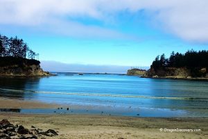
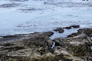
This quiet, scenic coastline is bordered by colorful cliffs and sea stacks, where distinct sandstone, siltstone, and shale formations tower above the golden sand and the restless ocean.
Yoakam Beach consists of two sandy pockets separated by composite-stone cliffs and bedrock reefs.
The more secluded easternmost stretch of the beach features dramatic rock walls, sea stacks, and even a small seasonal waterfall cascading from the cliffs after rainy periods.

Sitka spruce, huckleberry, sedge, wax myrtle, salal, and other coastal plants add vibrant color to the landscape.
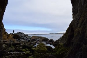
On the western edge of Yoakam Beach, cliffs and a wave-cut platform form a natural boundary with Lighthouse Beach.
During extremely low tides, it may be possible to cross this rocky barrier and reach the neighboring beach, where additional coastal scenery and closer views of the Cape Arago Lighthouse can be enjoyed.

How to Get to Yoakam Point
The only indication of beach access is a small "Day Use Only" sign in a narrow pullout about 0.3 miles west of the entrance road to Bastendorff Beach. You can park on both sides of the highway, but the parking areas are small and can accommodate only a few cars.
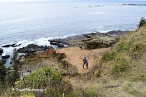
A 300-yard trail leads from the pullout to the viewpoint through a verdant coastal forest is straightforward. However, reaching the beach requires descending a steep, informal trail with rough rock steps. In several places, the steps disappear, and a rope is provided for support.
The path may become muddy and slippery, especially during wet seasons, and may be challenging for older visitors or those with limited mobility.
Use caution, wear sturdy footwear with good traction, and always check tide conditions before exploring the beach.

How to See Cape Arago Lighthouse
If you hike to the south end of Yoakam Beach, you can enjoy the Cape Arago Lighthouse. Visiting Lighthouse Beach during low tide offers the best chance to get as close as possible to the lighthouse.
The nearby Lighthouse Viewpoint, located about 1.7 miles along Cape Arago Highway, also provides a scenic view of the lighthouse.
Lighthouse Beach Access Dispute
Property owners have restricted the traditional access to the beach with locked gates, leading to ongoing disputes about public access.
Currently, the only ways to reach Lighthouse Beach are during very low tide by walking along Yoakam Beach.

Yoakam Point - Things to Do
Both Yoakam and Lighthouse Beaches are among the most scenic and secluded on the South Oregon Coast, offering breathtaking natural coastal beauty. You can walk along the beach, enjoy a picnic, or look out toward the distant Cape Arago Lighthouse on clear days.
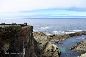
For those seeking a longer and refreshing hike, an easy 1-mile loop trail with about 30 feet of elevation gain leads to Yoakam Point headland. From here, visitors enjoy splendid views of Cape Arago Lighthouse, Mussel Reef, Bastendorff Beach, and the Coos River South Jetty.
The coast here is excellent for surf fishing and surfing, though carrying all the gear down to Yoakam Beach can be challenging.
At low tide, colorful tide pools reveal a variety of marine life, with ocean flora and fauna left behind until the water returns. on the South Oregon Coast offering breathtaking natural coastal beauty. You can walk along the beach, have a picnic, or look out toward the distant Cape Arago Lighthouse on clear days.

Yoakam Point Camping, Lodging & Vacation Rentals
No camping is permitted at this site. The nearest campgrounds are found at Bastendorff Beach County Park and Sunset Bay State Park.
The closest lodging and vacation rentals can be found in Charleston, North Bend, and Coos Bay.
Affordable vacation rentals for short and long term stay at Charleston and North Bend
Yoakam Point State Park | Facts
Open: Year-round
Managed by: Oregon State Parks
Amenities: None
Activities: Hiking, nature viewing, and picnicking
Distance from the parking: Short
Road access: Any passenger vehicle
Day-use fees: None
Yoakam Point State Park is located:
- 11 miles southwest of Coos Bay
- 50 miles north of Port Orford
- 82 miles northwest of Roseburg.
Adventures Nearby


Directions to Yoakam Point State Park
From North Bend,
- Take 540/South Empire Blvd for about 7 miles.
Your destination will be on the right.