

• Devils Lake is the shallowest of the Cascade Lakes and is easily accessible
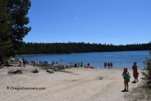
Devils Lake is a small, glowing turquoise gem nestled in Oregon’s Cascade Mountains, just 29 miles west of Bend in the Deschutes National Forest. Sitting at 5,450 feet, this shallow lake spans approximately 23 acres, with an average depth of only 3 feet and a maximum depth of 10 feet — making it one of the shallowest lakes in the region.
Its vivid color, often described as “devilishly green or blue,” is what gave Devils Lake its name. The first time I saw it, I thought it looked like a bottle of blue Gatorade poured into a mountain bowl. It’s part of the Cascade Lakes Scenic Byway, a route that links some of Central Oregon’s most stunning alpine lakes.
Formed by glaciers thousands of years ago, Devils Lake is now a beloved destination for hikers, anglers, kayakers, and photographers. With easy access directly off the highway and dramatic views, it’s the perfect spot to relax, explore, or launch into a classic Central Oregon adventure.

Outdoor Activities at Devils Lake
Fishing
Fishing at Devils Lake, Oregon is ideal if you want easy access and a quiet, relaxed setting. The lake is stocked annually with rainbow trout and also supports a native population of brook trout. Most catches are in the 8–12 inch range, but larger fish occasionally show up. Especially early and late in the season.
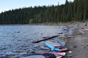
Only non-motorized boats are allowed, so the lake stays peaceful and clear. Bring a float tube, kayak, or canoe for the best access.
Hiking
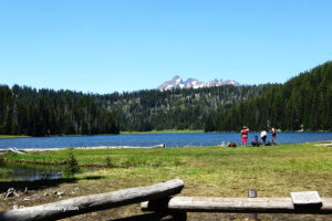
A 1.6-mile out-and-back trail follows the shoreline, offering easy walking and lovely views of Devils Lake and the surrounding pine forest. It’s mostly flat, with just a few mild ups and downs—more like a nature walk than a hike.
You will find wildflowers in early summer and might spot Steller’s jays, woodpeckers, or chipmunks. I often walk it with my dog, stopping for photos and finishing the loop in under an hour.
Tip: For a more challenging adventure, cross the highway to the South Sister Trailhead. This iconic hike climbs Oregon’s third-highest peak (10,358 ft), or you can turn around at Moraine Lake, about 6 miles out-and-back, for dramatic mountain views.

Kayaking & Boating
Kayaking and canoeing is wonderfully peaceful. The water is so clear, you can see the lakebed almost everywhere.
The lake's shallow depth and lack of motorboats create calm conditions, making it perfect for beginners or anyone who just wants to drift and relax.
Winter Sports at Devils Lake
From November to late May, the Cascade Lakes Scenic Byway is usually closed due to heavy snow accumulation. But you can still access the lake by cross-country skiing or snowshoeing from Mount Bachelor.
In winter, the lake transforms into a serene, snowy wonderland with quiet, untouched, and perfect for solitude or backcountry exploration.

Devils Lake Camping and Lodging
Camping at Devils Lake is perfect for those who enjoy a simple, no-frills night in the woods.
The walk-in Devils Lake Campground has just 10 tent-only sites, nestled in the trees near the water. It’s quiet, peaceful, and very basic.
You'll find a vault toilet and picnic tables, but no drinking water (so bring all you need!). There are no RVs allowed and no hookups. A Northwest Forest Pass is required for parking at the trailhead.
If you’re looking for more comfort, consider staying at one of the Cascade Lakes resorts nearby or heading back to Bend for hotels, motels, or vacation rentals.
Cascade Lakes Scenic Byway Map
Devils Lake | Facts
Open: Late spring through fall (Cascade Lakes Highway closes in winter)
Managed by: U.S. Forest Service
Amenities: Vault toilet and picnic tables (some sites)
Activities: Fishing, hiking, kayaking, paddleboarding, birdwatching, picnicking, and camping
Distance from the parking: Short
Road access: Any passenger vehicle
Day-use fees: Yes or Interagency Senior/Access/Military Pass
Elevation: 5,450 ft (1,660 m)
Devils Lake is located:
- 29 miles west of Bend
- 110 miles east of Eugene
- 205 miles southeast of Portland.
Body of water: Glacial lake
Surface area: 23 acres (9.3 ha)
Shoreline: About 0.8 miles (1.3 km)
Maximum depth: 10 ft (3 m)
Adventures Nearby


Directions to Devils Lake
From Bend,
- Take SW Century Drive (Highway 372) west of Bend. This becomes the Cascade Lakes Scenic Byway (Highway 46)
- Drive about 29 miles to the signed turnoff for Devils Lake (just after the turnoff for Sparks Lake)
- Park in the lot next to the lake and walk to the shoreline or campground.
Arrive before 9 a.m. on summer weekends for the best parking!
Phone: 541-383-4000