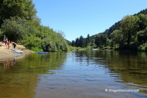
• The Alsea River water heats up quickly to comfort level for swimming
• The river attracts swimmers, boaters, and crayfish lovers
The Alsea River originates from the confluence of the North Fork and South Fork of the Alsea River near the Alsea town. Snaking down approximately 50 miles west on its way to the Pacific Ocean, the Alsea River, also, receives its water from other Coast Range creeks. The river was named after Alsi (Alsea) Native Americans, people who lived at the mouth of the Alsea River before the first Europeans arrived.
Alsea Highway 34 follows 43 miles along the river from the city of Waldport, providing convenient access to the river via numerous recreation sites and turnouts.
Accented by plenty of swimming holes, the Alsea River is relatively safe for swimming in the summer; thanks to its warmer water and slow current. Like other coastal Oregon rivers, the water heats up quickly to comfort temperatures for refreshing dips.
During the summer months, the Alsea River attracts swimmers, boaters, and crayfish lovers. A few spots along the river, which are suitable for many water activities including swimming, tubing, boating, and angling are listed below.
Video
Alsea River Swimming at Tidewater
One of the best swimming, tubing, and sunbathing spots is located between milepost 12 and 13 on Highway 34, about 12.9 miles east of Waldport. A short easy trail from the roadside turnout will take you to the river.
Punched with a lot of holes, flat rock ledges line the bank of the river. This flat bedrock outcrop serves as a platform for sunbathing and picnicking. There is a long cleft between underwater rock ledges, creating a brisk current and loads of fun for children.
Amenities: None
Day-use fees: None

Alsea River Swimming at Hellion Rapids
Travel a next couple miles east along Alsea Highway to the excellent swimming spot at Hellion Rapids.
Amenities: None
Day-use fees: None

Alsea River Swimming at Mike Bauer Wayside
Between milepost 16 and 17, just before the bridge, there is a parking area at Mike Bauer Wayside. You'll not miss it. A large turnout with a great view of the river with a short hike taking you down to it.
This spot features wide underwater ledges and a deep pool on the opposite side of the river. Mike Bauer Wayside is an accessible fishing site with a boat ramp and fishing platform.
Amenities: Vault toilet
Day-use fees: None

Blackberry Boat Ramp & Day Use | Campground
This site is located roughly 18 miles east of Waldport. Swimming and tubing are popular in the summer when the water level is low. Anglers will enjoy the river from the end of August through March. There is a boat ramp.
Amenities: Flush restrooms, potable water
Day-use fees: Yes or Interagency Senior/Access/Military Pass
Ermie Walter Boat Ramp
A small picnic site with a boat ramp, located between milepost 19 and 20 on Highway 34. A great place for wading and crawfishing. Large parking area.
Amenities: No service is available
Day-use fees: None

River Edge Recreation Site
The River Edge Recreation Site and Campground are located 23 miles east of Waldport. The site features an accessible group campground for 100 guests, a playfield, a large sheltered picnic area, campfire rings and grills, drinking water, electricity, and four vault toilets. Firewood may be purchased.
The site is excellent for a variety of water activities including swimming, wading, boating, and angling.
Amenities: Vault toilets, potable water
Day-use fees: Yes or Interagency Senior/Access/Military Pass

Missouri Bend Recreation Area
Missouri Bend Recreation Area can be found on Highway 34 between mileposts 31 and 32, about 7 miles west of the town of Alsea. A sturdy wooden staircase and wooden boat slide lead down from the parking area to the bank of the river.
The river is lined by rock ledges. Wading, swimming, sunbathing and crawfishing are available during the summer months. The day-use recreation area offers picnic tables.
Amenities: Vault toilet
Day-use fees: None

Alsea Falls on the South Fork of the Alsea River
 The scenic 30-foot Alsea Falls in the old-growth lush forest is a must-visit attraction for those who love the sound of cascading waterfalls and the tranquility of wild nature. The Alsea Falls Recreation Site is popular among campers, hikers, and all others who enjoy the beauty of wild nature.
Fishing
Alsea River is home to wild runs of coastal cutthroat trout, steelhead, chinook and coho salmon. The fish trout hatchery is located on the North Fork Alsea River; Oregon Hatchery Research Center is on Fall Creek.
Adventures Nearby


Does anyone know of a company that arranges/shuttles/rents tubes for the Alsea?