
• The Chetco River is a popular destination for rockhounding enthusiasts
![]()
![]()
![]()
![]()
![]()
The Chetco River originates from tributaries in the Klamath Mountains, flowing 56 miles through the remote southwestern region of Oregon before emptying into the Pacific Ocean at Brookings. The Chetco River is named after the Chetco Native Americans who once lived near its mouth.
The river’s headwaters and the upper 44 miles are designated as Wild and Scenic. This remote stretch is known for its crystal-clear water, rare plant life, and challenging Class III to IV+ rapids. Guided five-day whitewater trips are available through this wild section.
The lower 11 miles of the river are classified as a recreational section.
The river carries minerals from the Upper Chetco River area, known for its numerous gold-quartz veins and serpentinite rocks.
The Chetco River offers a great opportunities for not only excellent rockhounding but for hiking, fishing, swimming, hiking, whitewater kayaking, camping, and picnicking.

Chetco River Rockhounding
The Chetco River is home to extensive gravels bars, particularly in its lower section. These areas offer easy access and excellent materials for rockhounding. White quartz and jasper are abundant here, with occasional finds of carnelian agate, petrified wood, and serpentine.
Typically, quartz is milky-white and sometimes contains mineral impurities, while large pieces of green, brown, and red brecciated jasper are scattered throughout the river gravels.
Several excellent spots along the lower Chetco River allow you to drive directly to the riverbank, including Social Security Bar, Alfred Loeb State Park, Miller Bar, Nook Bar, Redwood Bar, Gardner Bar, South Fork, and Low Water Bridge.

Chetco River Swimming
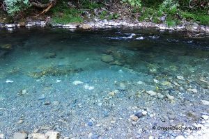
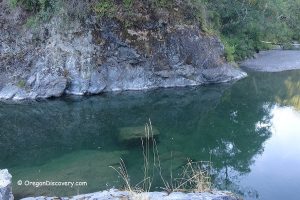
The lower section of the Chetco River is wider and slower, making it a safer place to swim during the summer. The river has clear, turquoise water that can warm up to about 80°F on hot days.
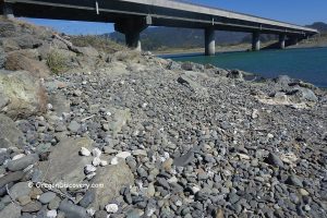
Sandy and gravel bars line the river, with both shallow areas for wading and deeper spots for swimming. You can also find natural jumping spots along the river, and salamanders are often seen in the shallow water.
Chetco River - Swimming & Other Water Activities on the South Oregon Coast
Chetco River Hiking
The Chetco River offers several hiking options for all skill levels.
Riverview Nature Trail in Alfred A. Loeb State Park is an easy 1.5‑mile round-trip hike that follows the river through lush forest and offers scenic river views.
Chetco Redwoods Loop is a family-friendly 2.6-mile hike through a grove of northernmost native redwoods connecting the riverside paths.
More adventurous hikers can explore the Chetco Gorge Trail, a moderate 1.7‑mile one-way route through a river gorge that may require fording the river in low-water conditions.

Chetco River Fishing
The Chetco River is one of Oregon’s top destinations for winter steelhead fishing, with runs typically occurring from December through March. Anglers may also catch Chinook salmon, as well as resident and sea-run cutthroat trout. Fishing can be done from gravel bars or by drifting in a boat.
Chetco Bay provides additional fishing opportunities. From shore or by boat, anglers can target salmon, steelhead, rockfish, perch, halibut, and even Dungeness crab.
Hiking and Kayaking: River’s rugged terrain provides opportunities for hiking and whitewater kayaking.
Camping and Picnicking: Numerous spots along the river are perfect for camping and picnicking, offering a chance to enjoy the scenic beauty of the area.
Chetco River Camping, Lodging & Vacation Rentals
Several campgrounds are available along the Chetco River.
Alfred A. Loeb State Park is a fantastic spot for camping by the river. It offers 53 electrical sites and 3 rustic log cabins, one campsite and one cabin of which are accessible. Each site features a picnic table and a fire ring. On-site amenities include firewood sales, hot showers, and flush toilets. Reservations are required and can be made through the Oregon State Parks Reservation System.
Other campgrounds including Redwood Bar, Nook Bar, and South Fork Campgrounds operate on a first-come, first-served basis. They offer fewer amenities compared to Alfred A. Loeb State Park.
For additional lodging options, the nearest accommodations are available in Brookings.
Affordable vacation rentals for short and long term stay in Brookings
Chetco River | Facts
Open: Year-round
Managed by: Bureau of Land Management & Oregon State Parks
Rocks & Minerals: White quartz, jasper, agate
Tools: Gem scoop, collecting bag
Distance from the parking: Short
Road access: Any vehicle
Fees: None
Elevation: 100-200 ft (30-61 m)
Adventures Nearby
Directions to Chetco River Gravel Bars
From Highway 101 in Brookings,
- Turn north to North Bank Chetco River Road and then bear right staying on North Bank Chetco River Road
- Travel 3.2 miles northeast to Social Security Bar on the right
- Follow the next 8 miles to Miller Bar
- Continue 3.4 miles to Redwood Bar.
Social Security Bar: N 42°3.853' W 124°13.799' | 42.064221, -124.229976
Miller Bar: N 42°08.347' W 124°10.742' | 42.139117, -124.179033
Redwood Bar: N 42°09.327' W 124°08.724' | 42.155450, -124.145401


