

• Fisher School Bridge is a charming historic bridge over the Five Rivers
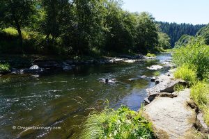
Fisher School Bridge, also known as Five Rivers Bridge, crosses the Five Rivers near the small community of Fisher, in the rugged Central Oregon Coast Range. You get there by winding forest roads off US‑20 and OR‑34. It’s a peaceful spot with cool air, green hills, and the gentle sound of the river. The bridge is 72 feet (22 m) long—small but very sturdy.
This Howe truss bridge keeps its classic look with curved entrance arches, narrow ribbon windows, and clean lines. After a complete repair, it now carries one-way local traffic, while a nearby concrete bridge handles the other direction.
The red siding looks brighter after rain, and light shining through the ribbon windows makes stripes on the deck. Photographers love this spot: the east side has soft morning light, and the west side has warm evening light.

Fisher School Bridge History
If you enjoy Oregon’s covered bridges, this one has an interesting local story. People aren’t sure exactly when it was first built. Lincoln County says it was made in 1919, but some think 1927 was the year it was rebuilt. Old records also list different costs, from $1,800 to $2,500. A local builder named Otis Hamer led the project, and nearby farmers helped by cutting large trees and shaping the logs with hand tools.
In the 1970s, the county planned demolition after a new concrete bridge went in. Locals rallied. Roy Olsen, a relative of the mill owners, pushed to save it. Lincoln County spent about $2,000 replacing rotted siding. The bridge survived.
But in 1998, an engineer said the bridge was unsafe. With help from a federal grant and ODOT, a major repair project started in 2001. Workers added new pilings, beams, a new deck, fresh siding, and a new roof. They also painted the bridge barn-red to match the local style.
During the 2003 reconstruction, the wooden trusses were found to be badly damaged, so the entire bridge had to be carefully moved about 50 feet downstream.
The project won first place for Rehabilitated Bridges. Today, the bridge rests on a new foundation adjacent to its original spot and remains open to one‑lane traffic.
The name comes from the nearby Fisher Elementary School, now a private residence across Crab Creek Road. Locals also call it the Five Rivers Bridge. Two former neighbors (Buck Creek Bridge and Cascade Creek Bridge) once stood within 2 miles, but only Fisher remains.

Why is this bridge so special?
Historic Significance: Built by Otis Hamer with local farmers; official year 1919 (renovation work noted in 1927); added to the National Register of Historic Places on November 29, 1979.
Still in Service: Open to one‑way local traffic; adjacent concrete bridge carries the other direction; relocated about 50 feet downstream in 2003 for structural safety.
Fisher School Bridge | Facts
Architectural Bridge Design: Howe truss
Bridge access: One‑way local traffic; adjacent modern bridge carries opposite flow
Stream: Five Rivers (fed by Alder, Cougar, Buck, Crab, Cherry creeks)
Bridge Length: 72 ft (22 m)
Built: 1919 (renovation noted 1927)
Elevation: 205 ft (62 m)
Fisher School Bridge is located:
- 38 miles west of Corvallis
- 20 miles southwest of Alsea
- 57 miles east of Newport.
Adventures Nearby


Directions to North Fork Yachats Covered Bridge
- Take Exit 228 for Corvallis/US‑20 W and drive 38 miles through Philomath
- At Eddyville/OR‑34, follow OR‑34 southwest through Alsea for 20 miles to Five Rivers‑Fisher Road (FS Road 141)
- At the Siletz Road fork, turn south; keep left past Buck Creek Road
- Continue about 1 mile to the bridge.