

• Gravel bars of the Lower Rogue River are great locations to search quartz, agate, and jasper
The Rogue River, one of two rivers in Oregon connecting the watersheds of the Cascades to the Pacific Ocean, offers a lot of opportunities for rockhounding.
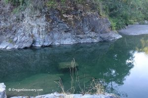
This article will describe the Lower Rogue River area that includes the beaches at the coastal town of Gold Beach and 35 miles up the river to Foster Bar. At this point, the paved road ends and the next 84-mile section of the river is designated as Wild and Scenic.
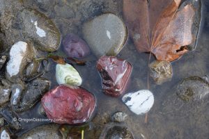
Along the Lower Rogue River, there are a few great sites with easy access and good-sized gravel bars where you can find a lot of excellent materials.
Agness
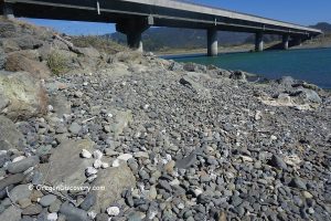
Agness Bar is an extensive gravel stretch located at the junction of Illinois and Rogue Rivers in the small community of Agness. The best time to explore the river bank gravels is the summer when water levels are low. The bar is well known for its abundance of white quartz, chalcedony, agate, and jasper. Petrified wood and gold might be found as well.
Travel 28 miles east on Jetty Flat Road which later becomes Agness Road to a bridge across the Illinois River at the small town of Agness. Park your car near the bridge and hike down to the river.
GPS (Agness Bar): N 42°33.008' W 124°03.839' | 42.550133, -124.063983


Lobster and Orchard Bars
Lobster and Orchard Bars are two neighbored giant gravel bars, situated 10 miles upstream from Gold Beach. This site is another great location to search for quartz, agate, jasper, and petrified wood.
Drive-up from Gold Beach on Jetty Flat Road for 10 miles to the dirt road on the left.
GPS (Lobster Bar): N 42°30.161' W 124°17.670' | 42.502683, -124.2945
Lobster Bar - Get Google Maps Directions
GPS (Orchard Bar): N 42°29.566' W 124°18.472' | 42.492774, -124.307868
Orchard Bar - Get Google Maps Directions
Gold Beach
The Rogue River enters the ocean at the small town of Gold Beach. One of the productive rockhounding areas on the Oregon Coast is the 2-mile shoreline, stretching south from the South Jetty of the Rogue River to Kissing Rock. The beach sits between the mouth of the Hunter Creek and the Rogue River and both rivers bring various materials to the beach.
This site is popular for agate, jasper, and petrified wood hunting. The best time to collect minerals is the winters, after winter storms, and during outgoing tides.
The name of Gold Beach comes from the gold mining past. The gold was discovered in sands near the mouth of the Rouge River. Though the gold deposit got depleted many years ago, you still can find a tiny piece of gold.
In addition to collecting of agate and jasper, you might enjoy searching for colorful glass floats. The annual festival Beach Treasure Hunt that is similar to the Finders Keepers Glass Floats Event in Lincoln City runs from February through April.
Explore other excellent beaches north of the Rogue River such as Otter Point Park (4 miles north of Gold Beach), Ophir Beach (11 miles north of Gold Beach), and Arizona Beach (17 miles north of Gold Beach).
Adventures Nearby

What is the concrete like rock on the banks of the lower lower Rouge?