• Picture Rock Pass Petroglyphs Site is a unique example of Indian culture
• Site has been used to tell local stories and for spiritual beliefs
![]()
![]()
![]()
![]()
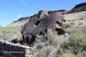
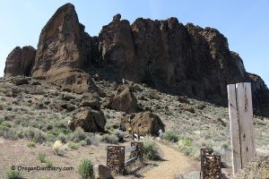
Picture Rock Pass Petroglyphs Site is located in Lake County of Oregon between two small incorporated communities of Summer Lake and Silver Lake along Oregon Route 31. The location of the boulder with ancient drawings is not clearly marked, but it is about 0.2-mile hike on the rocky Medicine Man Trail, near the summit of the Picture Rock Pass.
Native Americans carved into basalt rock very fine images. The meaning of these petroglyphs is uncertain, but there are a few ideas about it. Designs could have been used for ceremonial hunting, spiritual beliefs, indicating tribe migration routes, or marking their territory. Also, pictures could have been used to describe Indian history, tell local stories or myths. Drawings are estimated to be 7,500 and 12,000 years old.
A unique example of Native American culture, the site was placed on the National Register of Historic Places in 1975.
Warning. Preserving historical heritage is very important and it is the responsibility of every visitor. The petroglyph design is fragile and must be protected. In addition to straight vandalism, rarities can be damaged by careless visitors. Please, don't touch or rub artifacts and don't climb on the rock. Any alteration of the petroglyphs is illegal and considered to be a violation of federal law.


Picture Rock Pass Petroglyphs | Facts
Open: Year-round
Managed by: BLM
Location: Picture Rock Pass
Amenities: None
Activities: Hiking, nature viewing, photography
Distance from the parking: 0.2 miles (320 m)
Road access: Any vehicle
Day-use fees: Free
Popularity: Low to moderate
Elevation: 4,800 ft (1,463 m)
Picture Rock Pass Petroglyphs is located:
- 16 miles southeast of Silver Lake
- 95 miles southeast of Bend
- 171 miles east of Eugene.
Adventures Nearby
Directions to Picture Rock Pass Petroglyphs
From Silver Lake,
- Travel 16 miles southeast on Highway OR-31
- Turn right onto dirt road between milepost 63 and 64.
Park your car and hike 0.2 miles to the site.

