

• Borax Hot Springs is a geological phenomenon of the Alvord Basin
• Slightly alkaline water is extremely friendly to thermophilic microbes
![]()
![]()
![]()
![]()
Located in southeastern Oregon, Borax Hot Springs is one of the three main geothermal features of the Alvord Basin, alongside Alvord Hot Springs and Mickey Hot Springs, which lie 2 and 4 miles to the north, respectively. All three springs are part of the same active fault zone.
Set within a dramatic basin flanked by rotational fault blocks—the Steens and Pueblo Mountains to the west and the Sheepshead and Trout Creek Mountains to the east—the springs align precisely along the fault line. This alignment also includes numerous thermal vents and Borax Lake, also called Hot Lake.
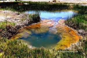
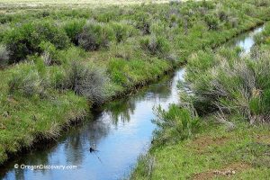
Spanning about 10 acres, Borax Lake is fed by a powerful geothermal spring that rises from depths over 100 feet (32 m). The outflow temperatures of the springs (specifically Borax Lake and associated vents) range from 104°F to about 196°F (40–91°C), while the lake's surface temperatures typically vary from 61°F to 100°F (16–38°C). The overflow from Borax Lake feeds into Little Borax Lake, sustaining a unique wetland ecosystem in this arid landscape.

Borax Lake's Industrial Past
Near the lake, rusting remnants of steel vats mark the site of an old borax extraction facility. In 1898, entrepreneurs Charles Taylor and John Fulton relocated their borax operation from Nevada’s Black Rock Desert to Hot Lake in southeastern Oregon—soon to be renamed Borax Lake.
They constructed two steel processing vats and employed around 30 Chinese workers to run the operation. Borax (sodium borate), collected from the lakebed and surrounding desert surface, was mixed with hot spring water from the lake’s center. To precipitate the borate, sulphuric acid was added, and the mixture was brought to a boil. As the solution cooled, pure crystalline borax formed and was later transported by mule train to Winnemucca, Nevada.
By 1907, the quality and concentration of sodium borate in the area had declined, making production no longer viable. The operation ceased, leaving behind the rusted industrial traces still visible today.


Unique Profile of Borax Hot Springs & Borax Lake
The unique geothermal ecosystem and mineral-rich environment of Borax Lake, with its significant sodium borate deposits, are attracting researchers to the area.
Numerous ecological, geochemical, geological, paleontological, mineralogical, and hydrological studies have been conducted. Surveys of aquatic invertebrates and geothermal microbes have taken place in the lake and its adjacent hot springs.
Scientists have monitored the population of the rare and endangered Borax Lake chub, which is found near the shore. This chub prefers cooler temperatures—around 85°F—and has survived and evolved in extreme environments for the last 10,000 years, existing only in Borax Lake and Lower Borax Lake.
The pH of the Borax water ranges between neutral and slightly alkaline, making it highly conducive to thermophilic microbes. These thermophiles are distributed based on temperature, and the ratio of chlorophyll to carotenoids creates colorful edges around the thermal pools.
For more information, read about the variety of pigmented bacteria found in the microbial mats of the hot springs.

The water of the hot springs contains the highest concentrations of sodium borate (borax), arsenic, and lead, making it unsafe to drink.
In 1993, The Nature Conservancy acquired 160 acres of private land, including Borax Lake, to protect the endangered Borax Lake chub and the fragile geothermal ecosystem.
The area is currently managed by The Nature Conservancy, the Bureau of Land Management (BLM), and the Oregon Department of Fish and Wildlife. As Borax Lake is a biological preserve, only foot traffic is permitted beyond the second gate.
Visitors are welcome to explore the site; however, swimming in the lake and soaking in the hot springs are prohibited due to health hazards and the need to preserve this exceptional and delicate ecosystem.
Cautions: The scalding temperatures, steam, and fragile ground surface - all of those make this place unsafe. The scalding temperatures, steam, and fragile ground surface make this area unsafe. Posted signs warn visitors to watch their step, as the thin ground could break underfoot and expose them to boiling water.

Borax Lake Camping & Lodging
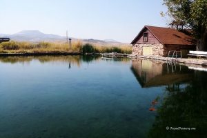
Camping is not allowed within the Borax Lake and Hot Springs area. However, primitive camping is available at Mann Lake and Alvord Playa. Alvord Hot Springs offers accommodation options, including campsites and bunkhouses.
The nearest lodging options are available in Hines or Burns.
Affordable vacation rentals for short and long term stay in Hines-Burns Area
Video
Borax Lake Hot Springs | Facts
Open: Year-round
Managed by: Bureau of Land Management (BLM)
Amenities: None
Distance from parking: 0.5 miles
Road Access: High-clearance vehicles, the road can be inaccessible during wet weather
Day-use fees: None
Elevation: 4,070 ft (1,240 m)
Borax Hot Springs and Borax Lake are located:
- 7 miles north of Fields
- 116 miles south of Burns
- 421 miles southeast of Portland.
Water T° (lake): 61°F (16°C)-100°F (38°C)
Water T° (hot springs): 104°-196°F (40°-91°C)
Water acidity level: Neutral to Weak Alkaline (pH=7.3 to 8.7)
Type of the springs: Sodium Sulfate Chloride
Average dissolved solids: 1,200 Mg/L
Sodium - 426 Mg/L
Sulfate - 329 Mg/L
Chloride - 265 Mg/L
Silica - 160 Mg/L
Potassium - 29 Mg/L
Calcium - 9.6 Mg/L
Flouride - 6.5 Mg/L
Alkanility - 425 Mg/L
Adventures Nearby


Directions to Borax Hot Springs
From Fields,
- Travel north 1.4 miles to the junction of Highway 205 and Fields-Denio Road (Folly Farm Road or East Steens Road)
- From the junction, bear right and go 0.25 miles to the power substation
- Turn right just after the power substation and follow the dirt road which parallels the power lines for about 2 miles
- Turn left and continue 0.9 miles to the first gate - open and close the gate.
- Go next 0.5 miles to the second gate.
From this point, the road is closed to all motor vehicles. Park your car and walk 0.5 miles to Borax Lake. Borax Hot Springs are located northwest of Borax Lake.
GPS (Borax Lake): N 42°19.642' W 118°36.265' | 42.3274, -118.6044
https://www.nature.org/ourinitiatives/regions/northamerica/unitedstates/index.htm
https://www.fws.gov
A.K. Koski, S.A. Wood The geochemistry of geothermal waters in the Alvord Basin, southeastern Oregon http://webpages.uidaho.edu/BioGeoChemistry/Kostgo.pdf
United States Department of the Interior Geological Survey. Chemical and Isotopic Data for Water from Thermal Springs and Wells of Oregon. 1980.
Proposed Determination that the Borax Lake Chub is an Endangered Species, Proposal Critical Habitat, Environmental Assessment (EA) B1; Final Rule. 1982.