
• Lake Billy Chinook was formed by constructing a dam that holds waters of three rivers
• A popular destination for swimming, fishing, water-skiing, picnicking, and hiking
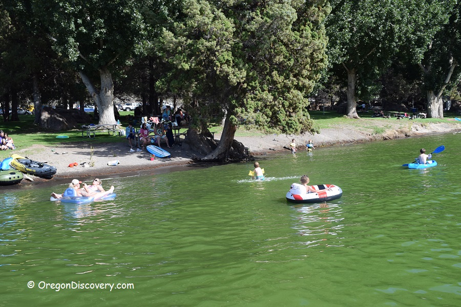
Scenic Lake Billy Chinook is a great year-round destination offering a variety of recreational activities including swimming, fishing, water-skiing, picnicking, and hiking. The lake is situated within a 500-foot-deep canyon framed by towering basalt cliffs that have been formed during millions of years by volcanic activities, weathering, and water erosion. Cove Palisades State Park surrounds a large portion of the lake.
Lake Billy Chinook with a 72-mile shoreline was created in 1964 when Portland General Electric completed the rock-filled Round Butte Dam on the Deschutes River that allowed to back up waters of three rivers - Deschutes, Metolius, and Crooked.
Swimming
Cove Palisades State Park has three day-use areas: Lower Deschutes, Upper Deschutes, and Crooked River. All day-use areas are located on the lakeshore and feature beaches and designated swimming and dock areas. The lake's shore and bottom are sandy. Lake weeds can be present in late summer.

Fishing
Lake Billy Chinook is known for a large variety of fish including wild kokanee, bull trout, smallmouth bass, rainbow trout, and german browns. Occasionally, an Atlantic salmon or catfish can be caught. There are also great crayfishing opportunities. The Crooked and Deschutes arms are open year-round, but the Metolius arm has a limited season and requires a tribal angling permit.
The Crooked River Day-Use Area has an accessible fishing platform according to the Americans with Disabilities Act (ADA).
Boating & Paddling
The lake is popular among boaters. You can bring your personal flotation device if it’s approved by a Coast Guard or rent motorized and non-motorized boats, stand-up paddle-boards, and even a house boat.

Hiking
The park offers over 10 miles of trails, from short connecting trails to the seven-mile Tam-a-lau Trail.
Tam-a-láu Trail
Moderate | 6 miles (9.6 km) loop | 600 ft (183 m) elevation gain
The Tam-a-láu Trail runs from the Upper Deschutes Day-use Area to the top of the Peninsula, a high plateau between Crooked and Deschutes Rivers. This trail offers spectacular views of the Cascades and the river canyons of the Deschutes and Crooked Rivers.
Wetland Nature Trail Loop
Easy | 0.25 miles (0.4 km) loop
Refreshing walk through a wetland restoration project after a wildfire in 2015.
Crooked River Rim Trail
Moderate | 2 miles (3.2 km) out & back | 210 ft (64 m) elevation gain
Crooked River Rim Trail offers great views of the Peninsula, the Crooked River canyon, and the snow-capped Cascade Mountains in the background.

Lake Billy Chinook | Facts
Open: Year-round
Managed by: Oregon State Parks
Location: Cove Palisades State Park
Services: Flush toilets, garbage service, fishing docks, boat ramps, playground, picnic sites
Activities: Swimming, watersports, hiking, fishing, boating, scenic viewpoints
Distance from the parking: Short
Road access: Any passenger vehicle
Day-use fees: Yes or parking permits for State Parks
Dogs: Must be on a leash
Accommodations: 256 campsites and RV sites, 3 deluxe log cabins, group tent area
Elevation: 2,000 ft (610 m)
Lake Billy Chinook is located:
- 11 miles west of Madras
- 41 miles north of Bend
- 131 miles southeast of Salem.
Facts
Body of water: Reservoir
Surface area: 4,000 acres
Shoreline: 72 miles (116 km)
Maximum depth: 400 ft (121 m)
Characteristics
Swimming hole rating: 3 out of 5
Water quality: Transparent
Current: None
Depth: Deep and shallow
Beach: Sand
Water T° (summer): Warm
Directions
From Redmond,
- Drive 15.7 miles north on US-97 to Culver Highway
- Bear left onto Culver Highway and go 0.8 miles to Jericho Lane
- Turn left onto Jericho Lane and follow 1.7 miles to Feather Drive
- Turn right onto Feather Drive and continue 2.5 miles to Fisch Lane
- Turn left onto Fisch Lane and after 0.5 miles turn right onto Fraizer Drive
- Go 0.5 miles to Peck Road/Jordan Road
- Turn left onto Peck Road/Jordan Road and continue 2 miles to Crooked River Day Use Area.
Address: 5700 SW Marina Dr, Culver, Oregon 97734


I was hoping we are still on a waiting list for one of the cabins this summer. Can you verify that? It would be under Kelley Kersch or Sean Murphy.
Thanks, Kelley