

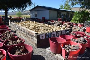
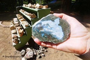
• Bear Creek Rockhounding Area is well-known for an abundance of petrified wood
![]()
![]()
![]()
Bear Creek, designated by the Bureau of Land Management as a recreational rockhounding area, is highlighted on the Central Oregon Rockhounding Map.
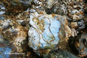
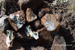
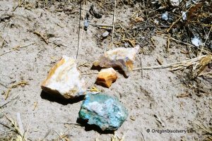
Located 13 miles north of the small town of Brothers, this site has long been popular among rock collectors for its abundance of petrified wood. The specimens found here range in color from black, brown, white, and gray to yellow, with some agatized petrified wood displaying striking yellow and red hues.
Site 1 is the more accessible and therefore more popular of the two main collecting areas. Covering 67 acres, it is bordered by fenced private land to the east, so be sure not to collect on private property.
While much of the wood scattered across the surface is of lower quality, it often shows fascinating details such as growth rings, cellular structure, and external bark. Higher-quality specimens can be found by digging 2 to 5 feet below the surface.
You can either start a new hole or continue digging in an existing one, focusing on the edges or deeper layers. The soil here is relatively soft, making excavation easier.


Site 2 offers a more challenging adventure. The road to this site is long, bumpy, and requires a high-clearance vehicle with four-wheel drive. However, the effort is well worth it.
This 474-acre site is located entirely on public land, allowing for exploration in all directions along a one-mile stretch of road. Because Site 2 is less accessible, it attracts fewer visitors, and as a result, often yields better-quality materials.

Bear Creek: Camping, Lodging, & Vacation Rentals
Primitive camping is allowed throughout public BLM land.
If you're prefer for more comfortable accommodations, consider lodging in Prineville, 40 miles southeast or in Bend, 46 miles east.
Affordable vacation rentals for short and long term stay in Bend
Bear Creek Rockhounding Area | Facts
Best time: May through October
Managed by: Bureau of Land Management (BLM)
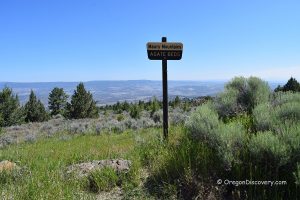
Location: Ochoco National Forest
Rocks & Minerals: Petrified Wood
Tools: Shovel, geology pick
Activities: Rockhounding, camping, and wildlife observing
Distance from the parking: Vary
Road access: A high-clearance 4WD vehicle, the road can be inaccessible during wet weather
Day-use fees: None
Elevation: 4,000-4,250 ft (1,219-1,295 m)
Bear Creek Rockhounding Area is located:
- 13 miles north of Brothers
- 40 miles southeast of Prineville
- 46 miles east of Bend
- 175 miles southeast of Salem.
Adventures Nearby

Directions to Bear Creek Rockhounding Area
From Prineville,
- Take Highway 27 and drive 33 miles to Bear Creek Road, 0.9 miles after you pass Little Bear Creek Road
- Turn left (east) onto Bear Creek Road and drive 5.3 miles to a dirt road on the left
- Turn left and follow 0.1 miles to the fork, bear right and continue 0.3 miles to a fence
- Open and close the fence behind you and drive 0.1 miles to the next fork where rockhounding signs are posted.
Site 1. From the fork, bear right and continue 0.5 miles to the pits on the left.
GPS (Site 1): N 43°56.450' W 120°37.146' | 43.940833, -120.6191
Site 2. From the fork, take the road on the left and go 2.5 miles to the south side of the collecting area. The designated rockhounding area is stretched next 1 mile along the road.
GPS (Site 2): N 43°57.629' W 120°36.516' | 43.960481, -120.608601
I attempted to go to Bear Creek to collect and I used the map I purchased (Central Oregon Rockhounding.) I attempted to go to site 2 first and I think I was in the right place but there was a closed wire fence across the road. I then attempted to go to site #1, and again found a closed wire fence.
I didnt want to take a chance and go through a closed gate and I don’t see anything here mentioning a gate and I didnt see any signage.
Was I in the right place? Was I supposed to open the gate and then close it behind me? According to the map, I was in the right place.
It was a very long drive from southern Oregon to get there. If the closed gate is normal, please list that in this description.
Thank you
There are a fence before a fork from where you can drive to Site 1 and Site 2.
I believe the fence prevents cattle from entering this area. No any ” No Trespass” signs.
Just make sure to close the fence/gate behind you.