Lower Cow Creek, Island Creek Day Use Area, Oregon
Island Creek Day Use Area

• Cow Creek Back Country Byway, along lower Cow Creek, offers a journey through history
• There are numerous spots for swimming, fishing, gold panning, and rockhounding

Cow Creek Back Country Byway is a 45-mile route connecting the interstate and the cities of Glendale, Riddle, and Tri City, making your loop-trip up or down I-5 more memorable.

This scenic route winds along lower Cow Creek that joins the South Umpqua River 2 miles west of Canyonville. Along your journey on the byway, you will encounter interpretive signs about the area's history. You will learn about gold mining in the area, the history of the 1869 railroad, and the forgotten town of West Fork.

Cow Creek Back Country Byway is a two-lane road with logging trucks frequently on it. Pay attention and be alert at blind corners. Also, be advised that the railroad is still in use.


West Fork Railroad Bridge

Multiple spots provide creek access and, as a result, potential for swimming and rockhounding. Those places include, but are not limited to, Island Creek Day Use, Cow Creek Gold Panning spot, West Fork Historic Site, Skull Creek, Cow Creek Rest Area, and so on.

Please be mindful of all of the signs. There are multiple private claims with no trespassing allowed. Also, federal claims prohibit gold panning for personal or commercial use.

According to BLM, the rights to the minerals on a mining claim do not include the surface rights to the land involved, so the general public may access the site for other recreational uses such as swimming, wading, or even overnight camping, as long as the activity does not interfere with a claimant's ability to work their mining claim.

Cow Creek Swimming, Island Creek Day Use Area, Oregon
Island Creek Day Use Area - Swimming Hole

Island Creek Day Use Area

Located about 8 miles southwest of Riddle, the Island Creek Day Use area provides fantastic outdoor opportunities in the scenic surroundings. This spot is great for picnicking, swimming, fishing, rockhounding, nature viewing, or simple relaxation. There is a picnic table and a vault restroom.

GPS: N 42°54.743' W 123°28.874' | 42.912383, -123.481233

Cow Creek Recreational Gold Prospecting

Cow Creek Gold Panning
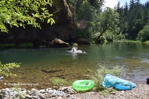
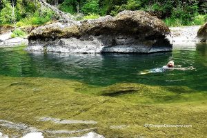
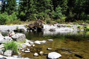
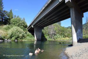
The creek contains gold and minerals that wash down from neighboring mountains during heavy rainfall runoffs. The Cow Creek Recreation Area, a recreational gold panning area, is located 21 miles southwest of Riddle. The 1,300-foot site allows public access for non-commercial gold panning and rockhounding.

Cow Creek Gold Panning & Rockhounding - Classical Prospecting Paradise

Cow Creek Gold Panning
Gold Panning

Riddle Rockhounding

Nickel Mountain Mine - Riddle Rockhounding
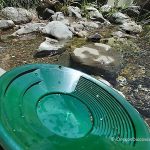
A big tailing pile of rocks right by the gate of an old nickel mine provides the opportunity to find garnierite and chrysoprase. The site is located at Cow Creek Back County Byway, 3 miles southwest of the small city of Riddle.

Nickel Mountain Mine - Riddle Rockhounding


West Fork & Cow Creek Railroad Bridges

Cow Creek Road passes through the old town of West Fork. Stop at interpretive signs to read about West Fork's history, gold fever, and the historic Siskiyou Line railroad, completed in 1882.

Two steel girder bridges over West Fork and Cow Creek were built in 1905. The railroad served local mines and lumber companies, as well as residents of communities that had existed but were now forgotten.

The railroad is still operating freight cars a few times every day.

Cow Creek Railroad Bridge: N 42°48.665' W 123°35.739' | 42.81161, -123.595650

West Fork Railroad Bridge: N 42°48.699' W 123°36.135' | 42.811650, -123.602250

Skull Creek Campground

Skull Creek Campground provides 5 camping sites on a first-come, first-served basis.

GPS: N 42°46.304' W 123°34.325 | 42.7717, -123.5721


Cow Creek Camping, Lodging & Vacation Rentals

When exploring Cow Creek, you can camp at Skull Creek Campground, one of the nearest developed camping areas to the creek along the Cow Creek Back Country Byway. This small, wooded campground offers a few first-come, first-served sites for tents and small RVs, tucked in among the trees close to the water.

The campground has basic amenities such as picnic tables, fire rings, and vault toilets, but there are no hookups, showers, or potable water, so visitors should bring their own drinking water and pack out all garbage.

You can also camp at Upper Cow Creek BLM dispersed sites, located at small pullouts and open spots along the creek. These informal areas offer level ground for tents and small trailers, as well as easy access to Cow Creek.

These dispersed sites generally have simple rock fire rings but no developed restrooms, water, or trash collection, so campers need to be fully self-sufficient and follow Leave No Trace practices.

Lower Cow Creek Rockhounding
Rockhounding

Another close option is the West Fork Cow Creek dispersed camping areas, which consist of small roadside and creekside clearings just off the byway. These spots are best suited to tent camping or small rigs and provide quick access to the creek and nearby trails.

Amenities here are minimal (typically limited to existing fire rings and natural seating areas) with no hookups or other facilities, making them a quiet but very rustic choice for staying near Cow Creek.

If you prefer more comfortable accommodations, Canyonville offers a variety of hotels and vacation rentals within a short drive of the creek.

Lodging in Canyonville

Affordable vacation rentals for short- and long-term stays

Adventures Nearby


Leave a Reply

Your email address will not be published. Required fields are marked *

This site uses Akismet to reduce spam. Learn how your comment data is processed.