

• The South Umpqua Bridge at Days Creek is a perfect roadside swimming hole
• You can find excellent minerals throughout the gravels here
The South Fork of the Umpqua River winds 115 miles from the high Cascades through the Umpqua National Forest canyon to Tiller and Days Creek. It flows through the South Umpqua Valley at Canyonville, and joins the North Umpqua River 8 miles northwest of Roseburg.
Though the scenic river offers a four-season experience, warmer months are the best for a wide range of summer activities, including swimming, sunbathing, picnicking, rafting, and rockhounding.

The South Umpqua Bridge at Days Creek - Things to Do
Swimming
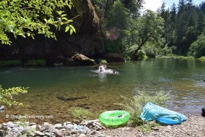
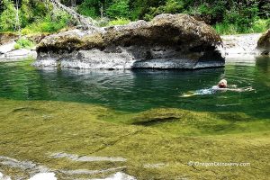
The South Fork of the Umpqua River near the unincorporated community of Days Creek is a perfect roadside swimming hole. The beach and swimming area sit under the bridge on the west bank. You can access the beach by a short trail that starts at the southwest side of the bridge and leads down under the bridge to the riverbank.
The river is deep here. The turquoise-colored water is transparent. The 4-foot rock across the river is used as a jumping spot.
Caution: Cliff jumping can be extremely dangerous. Variations in water levels, rocks that are not immediately visible, or even shifts in river bottoms due to strong currents can all lead to serious injury and death. Check current conditions and make safe decisions!

Rockhounding
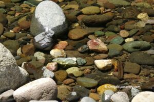
A gravel bar on the river's northeastern bank is a great place to find excellent minerals throughout the gravels, including quartz, agate, jasper, pyrite, and schist.
If you drive east, turn left as soon as you cross the bridge onto the dead-end road. You can park your car near the highway or drive to the end of the road, where you will find a hardly visible trailhead between blackberry bushes.
The path descends and then turns right before reaching the river. Follow the trail to the river gravel. The trail is very steep and can be slippery after rain, so it is not recommended for children or older visitors.

The South Umpqua Bridge at Days Creek: Camping, Lodging & Vacation Rentals
There is no camping at the bridge. Three C Rock Campground nearby has 8 first-come, first-served campsites with picnic tables and fire pits. There are also a vault toilet and a garbage disposal.
If you are looking for more comfortable accommodations, Canyonville, 7 miles away, has plenty of hotels and rentals to choose from.

South Umpqua Bridge | Facts
Open: Open year-round
Managed by: U.S. Forest Service
Amenities: None
Activities: Swimming, rockhounding
Distance from the trailhead: Short
Road access: Any passenger vehicle
Day-use fees: None
Elevation (waterfall): 760 ft (232 m)
South Umpqua Bridge is located:
- 34 miles east of Roseburg
- 77 miles north of Medford
- 105 miles southeast of Eugene.
Water Characteristics
Swimming hole rating: 4 out of 5
Body of Water: River
Water quality: Transparent
Current: Light to moderate
Depth: Deep
Beach: Sand & pebble
Water T° (summer): Cool (70°F in August)
Adventures Nearby


Directions to South Umpqua Bridge
From I-5 in Canyonville,
- Take exit 98 and turn left onto 1st Street
- Turn right onto Main Street and then onto 3d Street
- Continue 6.9 miles east on Douglas County Highway 1 to South Umpqua Bridge (at milepost 10) in Days Creek.
GPS (Trailhead to the rockhounding area): N 42°58.391' W 123°10.253' | 42.9732, -123.1709
GPS (Trailhead to the swimming area): N 42°58.342' W 123°10.361' | 42.9724, -123.1727