• Multnomah Falls is the tallest waterfall in Oregon
• The area is known for its scenic hiking trail to the waterfall top
No wonder that Multnomah Falls is one of the most visited natural recreation sites in Oregon. The place offers magnificent views, interesting hiking trails, and a peek into the exciting geological history of the region.
Multnomah Falls is located on the Oregon side of the Columbia River Gorge, just 30 miles (48 km) east of downtown Portland, along the Historic Columbia River Highway with easy access from I-84 (Exit 31) and Hwy 30 (Exit 17).
Multnomah Falls owes its existence and shape to the late Pleistocene Missoula Floods, the most significant floods ever to occur on Earth.

Missoula Floods were caused by a repeated breach of an ice dam, which blocked the present-day Clark Fork River and formed a huge glacial lake known as Lake Missoula. The lake's waters rushed down the Clark Fork and the Columbia River at a speed approaching 80 mph (130 km/h), flooding eastern Washington and the Willamette Valley up to present-day Eugene, Oregon, and beyond.
After the rupture, the ice would reform, thus restoring Lake Missoula until the next breach of the dam. Geologists estimate that the flooding and ice dam reformation cycle lasted 55 years on average, with the existing evidence of at least 25 massive floods.
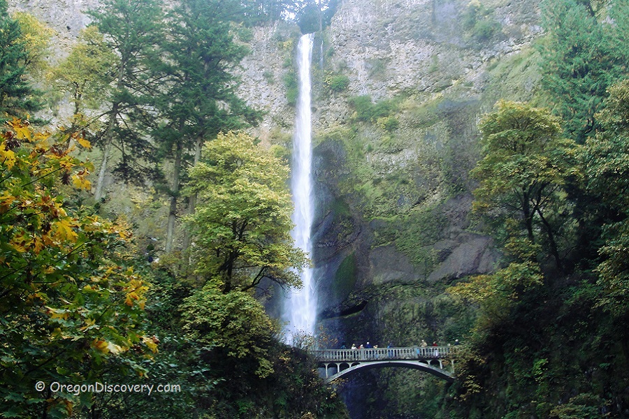
Multnomah Falls has two drops—the upper drop of 542 feet (165 meters) and the lower drop of 69 feet (21 meters). Together with the gradual 9-foot (3 meters) cascade in between, they make up the overall height of 620 feet (189 meters). According to the World Waterfall Database, this is the tallest waterfall in Oregon and the 137th tallest among both seasonal and year-round waterfalls in the United States. Among year-round waterfalls, Multnomah Falls is often regarded as the second-tallest.
Multnomah Falls is not seasonal like most waterfalls in Oregon. Natural underground springs from the Larch Mountains provide water throughout the year. Rainfalls and melting snow also contribute to the water flow, making Multnomah Falls larger, wider, and louder during winter and spring.

Multnomah Falls Hiking
In addition to the waterfall itself, Multnomah Falls is known for a scenic hiking trail. The trail starts at the base of the waterfall, goes through the Benson Bridge, and then follows up to the platform at the top of the upper cascade, where visitors can enjoy the bird’s eye view on the Columbia Gorge.
The overall length of the trail is around 1.3 miles (2.6 miles for a round trip). Once on the top, visitors can either go back or follow another trail. The difficulty of the Multnomah Falls trail is estimated as moderate, and in good weather conditions is safe for children and dogs.

Multnomah Falls Lodge and Parking
Located near the waterfall, the historic Multnomah Falls Lodge does not offer overnight accommodations. It functions as a day-use facility featuring a restaurant, gift shop, snack bar, espresso bar, and visitor center. Overnight stays are not available on-site.
To book a dining reservation at Multnomah Falls Lodge, you can call in advance 503-695-2376.
Please note that parking is limited between May 26 and September 1, 2025, and a Timed Use Permit is required for vehicle access between 9:00 a.m. and 6:00 p.m.. However, the permit does not guarantee a parking spot. Visitors arriving by shuttle services or bicycle are not required to obtain the permit.

Multnomah Falls Accomodations
To get the best view of Multnomah Falls and have a memorable stay, you have several great accommodation options nearby which add to your impressions to your memory. You have a great choice from cozy lodges and hotels to hot springs resorts. Here are some of the top choices.
Bonneville Hot Springs Resort & Spa
 Tucked away in the lush Columbia River Gorge, just 9 miles from Multnomah at the Washington–Oregon border, Bonneville Hot Springs Resort offers a peaceful retreat surrounded by forested hills and fresh mountain air.
Best Western Plus Columbia River Inn
Situated about 12 miles east of the waterfall, this hotel offers comfortable accommodations, complimentary breakfast, an indoor pool, and a fitness room.
Columbia Gorge Inn
Located approximately 12 miles away, the historic hotel offers convenient access to the waterfall and the surrounding Columbia River Gorge. It’s a great lodging option for travelers looking to explore the region while enjoying a comfortable stay.
Carson Hot Springs Resort
 Located 18 miles from the waterfall, Carson Hot Springs Resort is a historic resort located at the Columbia River Gorge offering a thermal bathing in the mineral-rich water.
Multnomah Falls | Facts
Open: Year-round; Visitor Center Hours:Everyday, 9 am - 5 pm
Managed by : US Forest Service
Amenities & Services: Restaurant, snack bar, espresso cart, gift shop, ant restrooms
Activities: Hiking, nature viewing, picnicking
Accommodations: Multnomah Falls Lodge
Distance from the parking: Short
Road access: Any passenger vehicle
Day-use fees: Free
Elevation: 627 ft (191 m)
Multnomah Falls is located:
- 32 miles west of Hood River
- 31 miles east of Portland
- 75 miles northeast of Salem.
Total height: 620 feet (189 m)
Total width: 10 feet (3 m)
Tributary: Underground springs
Watercourse: Multnomah Creek
Number of drops: Two
Average flow rate: 150 cubic feet per second (4.2 m3/s)
Primary form: Tiered plunges
Pitch: 90 degrees
Seasonality: 12 months
Adventures Nearby
Directions to Multnomah Falls
From Portland,
- Head east on Interstate 84 to exit 31
- Park and walk south, underneath the interstate and railroad tracks to the Lodge and Visitor Center.
From Cascade Locks,
- Drive west on Interstate 84 to exit 35, Ainsworth State Park
- Follow the Historic Highway west 4 miles to the site's parking area.
Phone: (503) 695-2372
50000 Historic Columbia River Highway, Bridal Veil, Oregon 97010


