

• Shellburg Falls is a natural gem hidden in the Santiam Forest wilderness
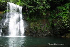
The 100-foot Shellburg Falls is a hidden gem deep within the ancient Santiam State Forest, along the scenic Stout Creek Canyon, just 30 miles east of Salem. Shellburg Creek plunges over a basalt ledge into a misty pool surrounded by mossy boulders and rocks.
A few hundred yards downstream, the creek spills again at Lower Shellburg Falls, which you can view from the Lower Shellburg Falls Trail near the bridge.
The Shellburg Falls Recreation Area, managed by the Oregon Department of Forestry, offers a variety of outdoor activities, including hiking, camping, biking, mountain biking, horseback riding, and picnicking—all while enjoying untouched scenery, waterfalls, and abundant wildlife.

Several connected trails wind through the area, totaling about 10 miles. There are three main trailhead parking areas; the first two mainly serve mountain bikers. If your goal is to hike to the falls, continue driving to the Shellburg Falls Day-Use Area, where hiking and biking trails meet.
From Highway 22, follow Wagner and Ayers Roads for about 5 miles to reach the Shellburg Falls Day Use Area. Keep in mind that the road is gravel, and some sections are rough, steep, and narrow.
During our last visit, Ayers Creek Road was gated, but we were able to find an alternative route using road signs and GPS. However, this detour added extra mileage, totaling 9 miles instead of the expected 5.
Note: There is no cell service in the forest, so be sure to download a map before you go.

Shellburg Falls Trails
From the Shellburg Falls Recreation Area, you have two options to reach the waterfall. The shortest route is the Upper Shellburg Falls Trail, which leads to the western side of the upper falls. The other option is to hike via the Lower Shellburg Falls Trail, which brings you to the base of both the upper falls and Lower Shellburg Falls.
Upper Shellburg Falls Trail
The Upper Shellburg Falls Trailhead is located at the lower parking lot of the Shellburg Day-Use Area. This 2-mile round-trip trail offers views from above or alongside the falls. The trail follows the stream and crosses two bridges. This intermediate-level trail is for hiking only and may be challenging for some hikers. During wet weather, steep sections can become slippery, so it’s essential to use good judgment and wear sturdy hiking boots.

Lower Shellburg Falls Trail via Vine Maple and August Mountain Trails
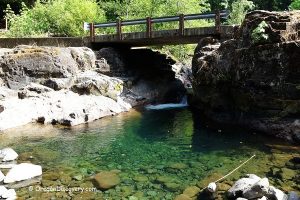
This 4.2-mile round-trip trail leads to the base of the upper falls. You can descend through moss-covered arches to an observation deck at the base of the upper falls or continue 0.15 miles to Shellburg Creek Bridge. This concrete bridge offers excellent views of the 40-foot Lower Shellburg Falls. This trail is considered to be of intermediate difficulty.

The Upper and Lower Trails connect together behind the waterfall inside a large grotto, naturally carved over thousands of years by the flowing water. Use caution during winter and early spring, as the cavern trail can become muddy and slick during high water flow.
| Update 2025
| The trail section behind the upper falls is currently closed due to structural concerns.

Vine Maple Loop Trail
This 0.8-mile loop trail for hiking only, starting at the day-use area near the upper level parking lot. The trail connects to both August Mountain and Shelburg Creek Trails.
August Mountain Trail
The August Mountain Trail is a 1-mile single-track that starts from the Vine Maple Loop Trail and leads to the 0.3-mile Lower Shellburg Falls Trail. This intermediate difficulty hiking trail is a little tougher than Vine Maple Trail but not extreme. It's a bit rougher and narrower than some of the other trails in the area, with exposed roots, rocks, and occasional muddy patches.
Shellburg Creek Trail
The Shellburg Creek Trail is a 1.2-mile multi-use trail for hiking, biking, and horseback riding. While there is no waterfall to enjoy on this trail, it will lead you through the picturesque forest and let you enjoy the beauty of local vegetation as well as see the forest’s fauna.
This trail links the August Mountain Trail and the Lost Lake Trail. The multi-use Lost Lake Trail is considered difficult and leads to Silver Falls State Park.
Note: During rainy weather, all trails can become slippery, so it's important to exercise caution. Be sure to wear sturdy hiking boots for better traction and safety.

Stasel Falls
Stasel Falls is a 125-foot waterfall tucked just 0.2 miles away from Lower Shelburg Falls, within Oregon's Santiam State Forest. This tiered horsetail waterfall features two distinct drops, each around 60 feet, and is fed by Stout Creek . Another feature of the falls is a freestanding basalt pillar.
From the bridge over Shellburg Creek, hike up 0.2 miles on Shellburg Road until the road begins to head uphill and to the left. On the left, you will see the sign for August Mountain Trail. Just across the road on the right, look for a trail between two large boulders. Follow this trail and take the left fork. Walk 0.15-mile and you will hear and see the cascading falls.
This trail isn't very well maintained and the viewpoint is located on an unprotected cliff, so it isn't recommended for children and inexperienced hikers.
Since the top viewpoint is on the public land but the waterfall itself is on the private land, you cannot trespass and explore its base.
| Update 2024
| The area south of Shellburg Road at the Stasel Falls currently located on the private property.

Shellburg Falls Camping and Lodging
Previously, Shellburg Falls Recreation Area featured a small campground with seven campsites, a hand-pump well, picnic tables, fire rings, grills, restrooms, and trash service. The campground was typically open from May through October.
| Update 2025
| As of April 2025, Shellburg Falls Campground is closed to overnight camping.
Another camping option is available at nearby Silver Falls State Park. Additionally, the nearby cities of Sublimity, Silverton, and Salem offer a variety of lodging options.
Video
Shellburg Falls | Facts
Open: The best time - from April to November
Managed by: Oregon Department of Forestry
Amenities: Picnic pavilion with tables and grills, vault toilet
Activities: Hiking, biking, mountain biking, horseback riding, nature viewing, and picnicking
Distance from the parking: Varies
Road access: Any passenger vehicle
Day-use fees: Free
Elevation: 1,400 ft (427 m)
Shellburg Falls is located:
- 30 miles east of Salem
- 70 miles southeast of Portland
- 80 miles northeast of Eugene.
Total height: 100 feet (30 m)
Total width: 10 feet (3 m)
Tributary: Underground springs
Watercourse: Shellburg Creek
Number of drops: One
Average flow rate: 20 cubic feet per second
Primary form: Plunge
Pitch: 90 degrees
Seasonality: 12 months
Adventures Nearby

Directions to Shellburg Falls
From I-5,
- Take exit 253 in Salem towards Detroit
- Travel 22 miles east to the first flashing light
- Cross a bridge and turn left onto Wagner Road between mileposts 22 and 23
- Keep right and follow Wagner/Ayers Creek Roads for 5 miles to Shellburg Falls Day Use Area.
During our last visit the Ayers Creek Road was gated but we found the route by road signboards and GPS (no cell service in the forest, download a map before you trip).
GPS (waterfall): N 44°48.728' W 122°36.488' | 44.8121, -122.608
GPS (Shellburg Falls Day-Use Area): N 44°48.765' W 122°36.475' | 44.8128, -122.608