

• A secluded Rock Creek swimming hole is hidden deep in the forest
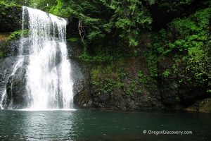
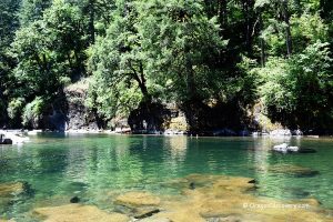
• Falls cascade off basalt cliffs and pour into a small but deep pool with clear green-emerald water
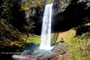
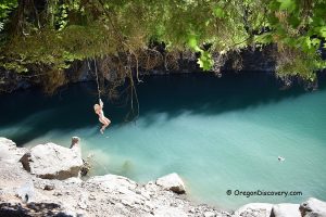
Discover a beautiful swimming hole on the Rock Creek, hidden deep in the ancient Santiam State Forest in the foothills of the Cascade Mountains. Surrounded by old-growth Douglas-fir, hemlock, red alder, and big leaf maple trees, the Rock Creek Recreation and three campsites offer secluded camping, picnicking, hiking, and swimming opportunities. You will drive in the wilderness roughly 3 miles along the creek on unpaved and gravel roads before you reach this amazing swimming spot.
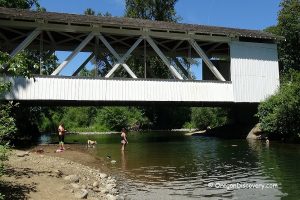
The hole is located below a footbridge. A beautiful waterfall cascades off the basalt cliff and pours into a small but deep pool with clear green-emerald water. You can access the swimming area either climbing down the cliff or use a trail on the left side of the bridge (a little longer but easy!).

The recreation area and campsites that are spread out along the creek offer seasonal restrooms, picnic tables, a garbage service, and fire rings. The gate is open for vehicles from May to September. For the rest of the year walk-in access is allowed beyond the gate. Nightly camping fees are applied. A day-use option is free.


Rock Creek Swimming Hole | Facts
Open: May - September
Managed by: Oregon Department of Forestry
Amenities: Portable toilets, no water, garbage service, and picnic sites
Activities: Swimming, hiking, picnicking, camping
Distance from the parking: Short
Road access: Any passenger vehicle
Day-use fees: None
Accommodations: No camping allowed near the swimming hole, 3 rustic campsites along the Rock Creek
Affordable vacation rentals for short and long term stay at Salem
Elevation: 1,496 ft (456 m)
Rock Creek Swimming Hole is located:
-
- 5.7 miles southeast of Mill City
- 38 miles east of Salem
- 84 miles southeast of Portland.
Swimming hole rating: 4 out of 5
Body of Water: Creek
Water quality: Transparent
Current: Light
Depth: Deep and shallow
Beach: River rocks, boulders, and basalt cliffs
Water T° (summer): Cool to warm
Adventures Nearby


Directions to Rock Creek
From I-5,
- Take exit 253 (Salem) for Highway 22 East
- Turn onto Highway 22 and drive 28 miles to Mill City
- Turn right onto 1st street and take a left, then right, and then slight left after crossing the bridge, staying on 1st Street
- Turn left on SE Kingwood Avenue and continue 2.1 miles to Rock Creek Road
- Turn right onto Rock Creek Road and follow 0.5 miles straight, then turn right (Rock Creek Camping Area sign)
- Drive 1.2 miles to the bridge, go left before the bridge. You will pass the gate.
- Drive along the creek 0.4 miles to the Rock Creek Recreation Area and then continue 1.1 miles to the next bridge (1.5 miles from the 1st to 2nd bridges).
The swimming hole is below the bridge.
Phone: 503-859-2151
Santiam State Forest