

• Larwood Covered Bridge is one of a few covered bridges near Scio
• It is the only place in the world where a river empties into a creek
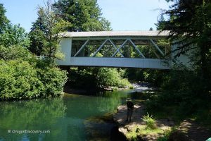
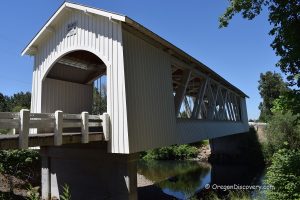
Larwood Covered Bridge over Crabtree Creek is one of the six beautiful covered bridges within a short distance from Scio and Stayton. It is located right by the Larwood Wayside Park at the junction of the Roaring River and Crabtree Creek. This place is unique since the river flows into the creek, not another way around, which is not common in nature. According to "Ripley's Believe It or Not", it's the only place in the world where a river empties into a creek.
Crabtree Creek begins in the western foothills of the Cascade Range near Crabtree Mountain and flows west to the South Santiam River.
The 111-foot Larwood Covered Bridge was constructed between 1939 and 1941 (no exact county record was found). It was named after William Larwood who founded the community near Crabtree Creek in 1888. Before this bridge was built, two covered bridges adjusted to each other spanned Roaring River and Crabtree Creek.

The bridge is crossed by Fish Hatchery Road and open to one-lane vehicle traffic. This made it a very well preserved piece of history you can enjoy nowadays. In 1979, the Larwood Bridge was added to the National Register of Historic Places.
There is one more covered bridge over Crabtree Creek – Hoffman Bridge, constructed in 1936.
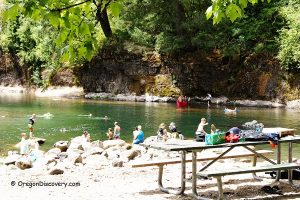
The 6-acre Wayside Park is a great swimming, fishing, and picnicking spot. There are a wooden footbridge over the Roaring River, a restroom, and picnic tables.

Swimming
Crabtree Creek below the Larwood Covered Bridge is a popular spot for those who like wading and swimming.
In the summer months, when the water level of the creek is low, this section of the river is calm. The large swimming hole features warm and clear water, sandy and rocky bottom, and a rope swing under the bridge. Some swimmers chose to jump off the bridge, but it can lead to serious injury since the deepest spot under the bridge ranges from 3 to 5 feet.

Fishing
The creek is closed to salmon and steelhead angling. Open to trout fishing from the end of May through the end of October, catch-and-release only.
Bass, crappie, bluegill, and yellow perch fishing is open during trout season. No catch limit.
Video
Larwood Covered Bridge | Facts
Architectural Bridge Design: Howe truss
Bridge access: Pedestrian and vehicle
Stream: Crabtree Creek
Bridge Length: 111 ft (34 m)
Built: 1939
Open: Year-round
Elevation: 400 ft (122 m)
Larwood Bridge is located:
- 19 miles east of Albany
- 32 miles southeast of Salem
- 64 miles northeast of Eugene.
Adventures Nearby


Directions to Larwood Covered Bridge
From I-5,
- Take exit 233 in Albany toward Sweet Home and drive 5.5 miles east on Highway 20 to Highway 226
- Turn left onto Highway 226 and go 4.4 miles to Fish Hatchery Drive
- Turn right onto Fish Hatchery Drive and continue 6.6 miles to the bridge, cross the bridge.
The parking area is located immediately after the bridge on the left.
Hi how please are the water levels at the park now August 10 to 20, 2024 ? Is there enough water now in the wading area ?.
I was there last Saturday.
The water level is low.