• Sheep Rock has the widest array of attractions and activities within the national park
• The oldest fossils found here are 33 million years old, while the oldest non-fossil rocks are 95 million years old
The Sheep Rock Unit, or just Sheep Rock, is one of 3 parts of John Day Fossil Beds National Monument. Two other units are Painted Hills and Clarno.
This is the largest part of the park with the most things to do and places to see.
Here, you will encounter unique landscapes with blue hills, mountains with layers of colorful rocks, a volcanic canyon with a rushing river, and other breathtaking landscapes.
Formation and Geology
There has yet to be a consensus on how long ago this area was formed, with an estimated range between 7 and 32 million years ago. However, this is the most geologically and paleontologically diverse part of John Day.
To this day, fascinating geology with many non-fossil and fossil rocks provides scientists with plenty of material to study and explore.
The landscape here periodically changes because of elements and erosion, bringing new fossils to light.
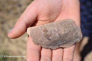
The oldest found non-fossil rocks are dated 95 million years old, while fossilized plants and animals here go as far as 33 million years ago.
You can see plenty of those pieces are on display in Sheep Rock's paleontology center.
Thomas Condon Paleontology Center
The Thomas Condon Paleontology Center doubles as a visitor's center and a fossil museum.
Here, you can see unique fossils discovered from local digs. Check out a series of dioramas and displays telling the geological and biological history of the area.
The museum also shows short films explaining the area's prehistory and current scientific research and discovery.
The Cant Ranch House
This is a 1917 ranch house made into a museum. It showcases the life of people on the ranch and in the surrounding area 100 years ago. The bunkhouse and log cabin next to the museum have fossil displays.
The shaded tree area near the ranch house is perfect for picnics. Also, the nearby trail will lead you to the John Day River.

Sheep Rock
Sheep Rock is a 6,847 ft (2,087 m) high summit and a landmark of the area. It consists of two separate layers of basalt contrasting with each other.
This formation was named after the bighorn sheep, which used to populate the rocky landscape.
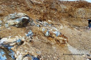
Cathedral Rock
This is an ancient pyroclastic lava flow and ash formation. The landslide removed some of the top rock, revealing softer blue and yellow material inside.
Such a unique color is created by celadonite and clinoptilolite.
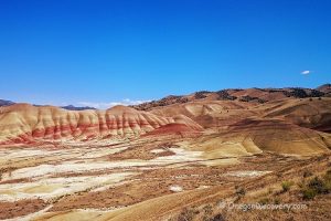
Blue Basin
Blue Basin is a blue-green, heavily eroded rocky badland devoid of vegetation.
The rock formations consist of blue-green and tan claystone and siltstones, creating unique colors. You can encounter a palette of shades from mint green to a darker, bluer green.
Blue Basin has one of the highest fossil deposits, including long-extinct species like saber-toothed tigers.
Mascall Formation
The 150 ft (50 m) viewpoint provides spectacular views of the John Day River Valley and Picture Gorge.
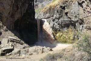
Picture Gorge
This is a scenic canyon where John Day River flows past 1,500-foot (457 m) high lava formations toward the Columbia River.
Foree Picnic Area
This picnic area has tremendous views and two hiking trails to explore green mudstone with basalt lava flows.

Hiking
Sheep Rock Unit has a lot of trails all through its territory.
The Thomas Condon Overlook Trail is a 0.25-mile (0.4 km ) out-and-back path. It starts and ends at the parking lot of Thomas Condon Paleontology Center.
The River Trail is a 0.6-mile (0.96 km) gravel out-and-back path from the museum parking lot to the John Day River.
The Sheep Rock Overlook Trail is a 0.25-mile (0.4 km) out-and-back hike. It starts from the main gate of The Cant Ranch House and leads to the river.
Blue Basin Area
Island in Time Trail is a 1.3-mile (2 km) gravel out-and-back trail taking you through Blue Basin.
Blue Basin Overlook Trail is a 3.25-mile (5.2 km) out-and-back hike with spectacular John Day River Valley views. The pathway can become impassable in wet and rainy weather. Altitude change along the route exceeds 600 feet (183 m).
Foree Picnic Area
Flood of Fire Trail is a 0.4 mile (0.64 km) gravel out-and-back path leading to a viewpoint of the John Day River Valley and colorful hills.
The Story in Stone Trail is a short out-and-back 0.3 miles (0.48 km) trail along the base of the Turtle Cove formation with its blue-green claystone rocks.
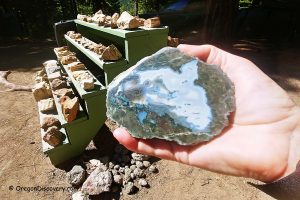
Rockhounding
The area is full of fossil and non-fossil rocks.
However, collecting fossils is generally prohibited.
There are recreational rockhounding beds in the town of Fossil and at Mt. Vernon, where you can legally find interesting rocks for your collection.
Sheep Rock: Camping & Lodging
Camping is prohibited anywhere at the John Day Fossil Beds National Monument. However, the surrounding area has multiple campgrounds, such as Bingham Springs Campground, Burnt Ranch Campground, and Antelope RV Park.
The small community of Dayville is the closest place to Sheep Rock with accommodations.
Kimberly, 17 miles north, and Mitchell, 32 miles west, are a bit farther but have more places to stay.
Alternatively, you can get a hotel in Prineville, 80 miles away. It is farther than the other towns but has the most extensive hotel selection in the area.
Affordable Vacation Rentals Near John Day Fossil Beds National Monument
Sheep Rock | Facts
Open: Year-round
Managed by: National Park Service
Amenities: Vault toilets, picnic tables, visitor center, fossil museum, bookstore
Activities: Rockhounding, hiking, nature viewing and picnicking
Distance from the parking: Short
Road access: Any vehicle
Day-use fees: None
Popularity: Moderate to High
Accommodations: Lodging at Dayville and Mitchell
Elevation: Varies
Sheep Rock Unit is located:
- 33 miles west of Mitchell
- 228 miles southeast of Salem
- 232 miles southeast of Portland.
Adventures Nearby


Directions to Sheep Rock Visitors Center
From Dayville,
- Take US-26 W/Franklin Street for 6.9 miles
- Turn right onto OR-19 N and follow it for 2 miles
- Turn left towards the visitors' center.
There are multiple parking lots at Sheep Rock. Consult the visitors center and follow the signs.