

• Umpqua Hot Springs sits perched on a cliff overlooking a stunning river canyon
• The vibrant travertine deposits, created by the mineral-rich waters
![]()
![]()
![]()
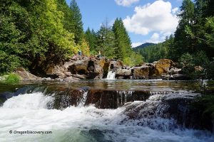
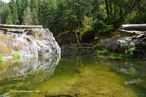
Umpqua Hot Springs is one of the many geothermal mineral springs in the Cascade Mountains, and it is widely considered one of the most beautiful. The hot spring pools are perched on a cliff, offering stunning views of the North Umpqua River canyon.
While the exact way Native American tribes utilized the hot springs remains unclear, we know that at least four tribal groups lived along the river. Despite any conflicts between them, all tribes would set aside their differences to visit the springs for healing and spiritual purposes.

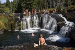
Some visitors note that the springs can be a bit tricky to find due to several turn-offs along the way. However, with the signs provided, you can easily navigate your way there. Once you reach the parking area, a short 0.3-mile walk will take you to the springs. The path is steep and can be slippery, so be sure to wear appropriate footwear.
The natural mineral water emerges from an active fault at a temperature of up to 115°F. This slightly acidic geothermal water, with a high mineral concentration (8,000 ppm), creates the colorful travertine deposits that make the springs so unique.

Umpqua features eight pools of varying sizes, with water temperatures ranging from 100°F to 108°F. The sheltered pool, measuring 6 by 6 feet in diameter and 2 feet in depth, is surrounded by wooden beams with a large opening on one side. Hot water is directed into the pool via a hose, and if the water becomes too hot, it can be cooled by adjusting the hose's flow.
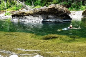
Smaller pools cascade down the hillside, with the water temperature decreasing as you move further toward the river. At the riverbank, you'll find another pool tucked inside a vibrant travertine grotto.
Be cautious when moving between pools, as the mineral-covered cliff can be very slippery.
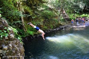
There are also several hiking trails that pass near Umpqua Hot Springs, allowing visitors to enjoy the surrounding natural beauty.

Umpqua Hot Springs: Camping, Lodging & Vacation Rentals
Camping is not allowed near the trailhead. The nearest campground is located 3 miles southwest at Toketee Lake. Toketee Lake Campground is open year-round on a first-come, first-served basis, though reservations are required during the busy period from June to Labor Day via recreation.gov.
The campground offers picnic tables, fire pits, vault toilets, and a boat ramp, but please note that no drinking water is available.
The nearest accommodations are available 60 miles away in Roseburg.
Affordable vacation rentals for short and long term stay at Roseburg
Video
Umpqua Hot Springs | Facts
Open: Year-round from sunrise to sunset; the gate can be closed due to snow or road conditions
Managed by: U.S. Forest Service
Development: Undeveloped, sheltered pool
Amenities: None except pit toilet
Activities: Soaking, hiking, fishing, and rafting
Clothing: Optional
Distance from the parking: 0.3 miles
Road Access: Any vehicle
Day-use fees: Yes or Interagency Senior/Access/Military Pass
Elevation: 2,640 ft (805 m)
Umpqua Hot Springs is located:
- 63 miles east of Roseburg
- 121 miles southwest of Bend
- 130 miles southeast of Eugene.
Water T° (source): 115°F (46°C)
Water T° (pools): 100°F (38°C) to 115°F (46°C)
Water acidity level: Weak acidic (pH=6.37)
Type of the springs: Sodium Chloride Carbonated
Flow rate: 20 l/min
Chemical used: None
Average dissolved solids: 8,000 Mg/L
Chloride - 3,500 Mg/L
Sodium - 2,400 Mg/L
Carbonate -1,380 Mg/L
Calcium - 340 Mg/L
Sulfate - 190 Mg/L
Silica - 90 Mg/L
Potassium - 63 Mg/L
Magnesium - 41 Mg/L
Boron - 2.4 Mg/L
Fluoride - 1.5 Mg/L
Iron - 0.01 Mg/L
Adventures Nearby


Directions to Umpqua Hot Springs
From Roseburg,
- Drive 68 miles east on OR-138 to Toketee-Rigdon RD (Forest Road 34)
- Turn left at milepost 58.4 onto FR 34
- Turn left across the concrete bridge and continue 2.2 miles onto North Umpqua Road and Basket Buttle Road to Forest Road 3401
- Turn right onto FR 3401 and drive 0.7 miles to a parking area on the left.
From the parking area at the trailhead, cross the footbridge over the river to reach the trail. Turn right and walk 0.1 miles to a junction. At the junction, turn right again and begin climbing a steep, narrow trail for 0.2 miles.
GPS (Hot Springs): N 43°17.811' W 122°21.822' | 43.2968, -122.3637
GPS (Trailhead): N 43°17.602' W 122°21.905' | 43.293361, -122.365083
Lauren S. Forcella. "Geochemistry of Thermal and Mineral Waters in the Cascade Mountains of Western North America". 1981
USDA Forest Service. fs.usda.gov