• Bagby Hot Springs is a small fairy-tale alike place
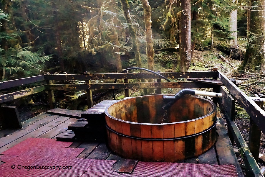
• Features primitive facilities and wooden bathtubs
![]()
![]()
Located in the dense woods of the Mount Hood National Forest, Bagby Hot Springs offers a tranquil, almost fairy-tale-like escape just a short distance from cities such as Portland, Salem, and Vancouver. This picturesque getaway, with its primitive facilities, takes you back to a simpler time.
There is no direct parking or camping at the hot springs, so a refreshing hike is required. Parking and camping are available at the Bagby Trailhead, approximately 1.4 miles from the hot springs. The hike takes about 45 to 60 minutes at a moderate pace through the stunning old-growth forest.

The hot spring is open year-round. However, weekends and holidays can get busy, and you may need to wait for a vacant tub. Law enforcement officers regularly visit to ensure compliance with the rules.
The hot springs feature three bathhouses. The main bathhouse, also known as the Private Deck, is the most popular, as each tub is enclosed in its own private room. The Lower Bathhouse Deck holds four original tubs salvaged from a fire in 1979 and is considered a communal soaking area. The farthest bathhouse is also used for communal soaking.
Hot mineral water flows from two sources at a temperature of about 136°F and is directed through wooden flumes to the bathhouses. These flumes are hollowed-out cedar logs, 10 feet long and up to 3 feet in diameter. The geothermal water is too hot for soaking and must be mixed with cold water from nearby springs.
Public nudity is not allowed. Alcohol and marijuana are prohibited.

Bagby Hot Springs: A Brief History
The natural hot springs in this area have served as a healing and rejuvenating retreat for Native Americans over centuries. The discovery of this remarkable spot is credited to hunter Bob Bagby, who, in the 1880s, not only found it but also used for therapeutic purposes.
In 1913, the guard station was erected near the hot springs, primarily for the purpose of fire patrol during the summer fire seasons.
In the 1920s, Forest Service employees built a bathhouse and cabins to utilize the benefits of the hot springs.
In 1974, a new guard station was built in Oak Grove, and the Bagby Guard station underwent renovations, earning a place on the National Register of Historic Places. However, public access to the building was restricted.
The bathhouse and cabins were actively used until the fire in 1979 which burned wooden structures to the ground. It happened because one of the bathers accidentally left candles burning. It took over 5 years to rebuild the original bathhouse, along with the additional bathhouses that now provide a great opportunity to use the incredible benefits of the Bagby's mineral hot water.

Bagby Hot Springs: Camping, Lodging & Vacation Rentals
Camping is not allowed at the hot springs. The backcounty camping is permitted 0.25 miles away at Shower Creek.
Bagby Campground at the Bagby Trailhead is operated on the first-come, first-served basis. This is the tent camping with picnic tables and toilets.
Kingfisher Campground is located 4 miles east.
Lodging is available 38 miles away in Estacada.
Affordable vacation rentals for short and long term stay at Estacada
Video
Bagby Hot Springs | Facts
Open: Year-round, trails can be closed in winter
Managed by: US Forest Service
Development: Primitive, rustic bathhouses, and wooden tubs
Amenities: Pit toilets
Clothing: Required
Distance from the parking: 1.4 miles
Road access: Any passenger vehicle
Day-use fees: Yes for soaking; No day-use passes accepted
Elevation: 2,280 ft (695 m)
Bagby Hot Springs is located:
- 38 miles southeast of Estacada
- 67 miles southeast of Portland
- 89 miles east of Salem.
Water T°: 120°F (49°C) - 138°F (59°C)
Water acidity level: Alkaline (pH=9.7)
Type of the springs: Mixed
Flow rate: 26 gallon/min (100 l/min)
Chemical used: None
Average dissolved solids: 260 Mg/L
Silica (SiO2)- 81.5 Mg/L
Carbonate (CO3)- 68 Mg/L
Sodium (Na)- 54 Mg/L
Sulfate (SO4)- 30.7 Mg/L
Chloride (Cl)- 14.6 Mg/L
Bromide (Br)- 5 Mg/L
Calcium (Ca)- 3.7 Mg/L
Potassium (K)- 0.8 Mg/L
Fluoride (F)- 0.68 Mg/L
Boron (B) - 0.6 Mg/L
Magnesium (Mg)- 0.1 Mg/L
Adventures Nearby
Directions to Bagby Hot Springs
From Portland,
From I-205, take exit 12 in Clackamas and follow Highway 224 East.
From Salem,
Drive on Highway 213 to Molalla, turn right onto Highway 211. Before Estacada, turn right onto Highway 224.
- Drive 25.3 miles southeast on Highway 224 from Estacada (junction OR-224 and OR-224E) to Forest Road NF-46
- Highway 224 becomes road 46, bear right after the Ripplebrook Ranger Station and crossing the Oak Grove Fork of the Clackamas River
- Continue 3.5 miles on NF-46 to Forest Road 63, then turn right onto Forest Road 63
- Drive 3 miles to Forest Road 70 and turn right
- Follow next 5.5 miles to the Bagby Trailhead.
The Bagby Trailhead and parking facility are on the left.
Phone (US Forest Service): 503-630-6861
GPS (Hot Springs): N 44°56.120' W 122°10.422 | 44.9353,-122.1737
1. Lauren S. Forcella. "Geochemistry of Thermal and Mineral Waters in the Cascade Mountains of Western North America". 1981
2. "Geothermal Information Layer for Oregon". www.oregongeology.org
3. USDA Forest Service


