

• Big Eddy is a day-use area on the scenic Clackamas River
• Because of a strong current, an intermediate to advanced level of swim skills are required
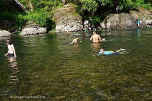
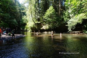
Big Eddy Day Use Area is a nice day-use site on the bank of the Clackamas River, offering opportunities to practice plenty of activities such as picnicking, fishing, swimming, sunbathing, and whitewater rafting.
There are a few picnic tables in open and shaded by maple tree areas. If summer picnics are incomplete without some splashing in the water, then the clear green Clackamas River waters provide a phenomenal cooling-off effect. That being said, some caution is to be exercised with regard to swimming in the river. There are rapids upstream and downstream. So, it is phenomenally important to ensure you stay upstream when frolicking in the water.

Portland General Electric warns of changing water levels and currents of all Clackamas River locations. Be sure you have moderate or better yet strong swim skills for safe swimming in the Clackamas River at the Big Eddy.
Another point of concern is that while the cold water of the river is perfect for relief from the heat all around, the water is quite cold, not higher than 60°F even in the peakk of the summer season. All in all, Big Eddy Day Use Area is the perfect spot to relax and picnic while enjoying the river and nature.


Big Eddy Day Use Area | Facts
Open: May - September from dawn to dusk
Managed by: USDA, Mount Hood National Forest
Amenities: Vault toilets, picnic sites
Activities: Swimming, rafting, fishing, picnicking
Distance from the parking: Short
Road access: Any passenger vehicle
Day-use fees: Yes or Interagency Senior/Access/Military Pass
Accommodations: Eagle Cove Camp
Elevation: 830 ft (253 m)
Big Eddy Day Use Area is located:
- 13 miles southeast of Estacada
- 41 miles southeast of Portland
- 65 miles northeast of Salem
- 136 miles northeast of Eugene.
Swimming hole rating: 3 out of 5
Body of Water: River
Water quality: Transparent
Current: Moderate to Strong
Depth: Deep and shallow
Beach: River rocks, formation rocks and pebbles
Water T° (summer): Cool
Adventures Nearby


Directions to Big Eddy Day Use Area
From Portland
- Drive on Highway 26 East to Sandy
- Turn right on Highway 211 and follow for about 6 miles to Highway 224
- Turn left onto Highway 224 East (HWY 211S) and continue 13.1 miles to the trailhead on the right between milepost 37 and 38.
From Salem & Eugene
- From I-5, take Exit 271 for Highway 214, and turn right onto Highway 214 toward Woodburn
- Continue on Highway 211 North for 33.2 miles to Highway 224 East
- Turn left onto Highway 224 East (HWY 211S) and continue 13.1 miles to the trailhead on the right between milepost 37 and 38.