• Fort Stevens was an active military installation until 1947
• The park offers opportunities for hiking, fishing, and various water activities
Located 10 miles west of Astoria, Fort Stevens was built in 1864 and remained an active military installation until 1947. It guarded the mouth of the Columbia River from the Civil War era until the end of World War II. The fort was named after General Isaac Stevens, a former governor of the Washington Territory, who was killed in Virginia in 1862.
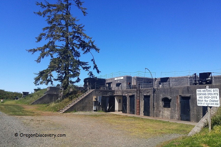
The military site saw significant development in the early 20th century. Eight concrete gun batteries and Battery Russell were constructed to defend the Oregon Territory. Battery Russell, located south of the other gun batteries, faced the ocean.

On Sunday, June 21, 1942, at 11:30 p.m., the Japanese Navy submarine I-25 bypassed the coastal waters of the United States and attacked Battery Russell. Approximately seventeen shells were fired in the direction of the battery. Fortunately, there were no serious consequences, just minimal property damage. It remains unclear why the soldiers received the order not to return fire.
Fort Stevens was the only continental U.S. military base to be attacked by a foreign army since the War of 1812.
After World War II, the fort was deactivated, equipment was removed, and some buildings were demolished, but almost all of the batteries are still available for exploration today.
The 4,300-acre Fort Stevens State Park has been open to the public since 1955.
Things to Do and See in Fort Stevens State Park
Historic Military Site
Take a walking tour and explore the primary military defense installation with massive concrete bunkers and other old structures. In the visitor center, you will see Harbor Defense System at the mouth of the Columbia River, old photos, weapons, and a scale model of the Battery Russell 10'' gun. Guided tours are available during the summer months.

Fort Stevens Hiking Trails
Fort Stevens State Park has nine miles of paved bicycle trails and six miles of hiking trails. The trail around Coffenbury Lake is easy and refreshing.
Coffenbury Lake Trail
The 2.4-mile loop trail around Coffenbury Lake offers an easy hike with no elevation gain. The trailhead is located at Coffenbury Lake's picnic area A.
If you cross the lake beach, on the right, you will find the trail. After 1.2 miles, turn left on an old road for 150 yards and keep left again. You also can start your hike from the picnic area at the northern lake's edge.

Battery Russell Trail
The 5-mile loop trail from Battery Russell is an easy to moderate hike with a 100-foot elevation gain.
Start by driving to the parking area at Battery Russell. Climb the staircase and walk to the far end of the concrete bunker, where you'll find a wide sandy trail leading to Coffenbury Lake. Stay right at all trail junctions. Follow the trail to a paved bike path, go right through a tunnel, and turn left to reach the picnic area at Coffenbury Lake. Then, take the 2.4-mile loop trail. After completing the loop, hike back to Battery Russell.

Delaura Dune Trail - a 4 miles hiking trail along the coast.
Kestrel Dune Trail - a 1.3-mile biking trail along the coast to Peter Iredale Shipwreck.
Shipwreck of Peter Iredale
 The skeleton of the shipwreck of Peter Iredale is a popular attraction within Fort Stevens State Park. Peter Iredale ran ashore on Clatsop Spit, south of the Columbia River channel on October 25, 1906. The wreckage is considered one of the most accessible and long-lasting in the world.
Coffenbury Lake
 Coffenbury Lake is a 56-acre typical coastal lake, containing water of rainfalls and snow. It was formed decades ago between dunes and receives its water from rain, snow, and irrigation.
Coffenbury Lake is a great destination for swimming, boating, canoeing, and paddling. Motorized boats with a 10 mph speed limit are permitted (gas-powered boats are not allowed). There are fishing docks, boat ramps, sandy beaches, and picnic sites.
Coffenbury Lake - A Tranquil Retreat in Fort Stevens State Park
Festivals and Events
 Civil War Reenactment in Fort Stevens State Park takes place at the beginning of September.
Wild Mushroom Identification and Guided Hikes happen a few times on weekends in October and November.
South Jetty | Clatsop Spit | Point Adams
The 9.7-mile rocky Jetties - South Jetty on the Oregon side and North Jetty on the Washington side were built between 1885 and 1895 to keep the mouth of the Columbia River from moving to prevent clogging the river mouth by sand.
Point Adams is situated at the southern edge of the mouth of the Columbia River. A large sand Clatsop Spit extends from the Point Adams to the northern edge of South Jetty. Drive from the Fort Stevens Park entrance for 3.9 miles to the parking area C at the jetty near Jetty Observation Tower. The 20-foot viewing platform provides an impressive view of the ocean, huge waves and a busy marine traffic along the South Jetty.


Fort Stevens State Park Camping and Lodging
Fort Stevens State Park has 476 campsites, including 170 with full hookups, over 300 with electricity and water, six tent sites near the water, 15 yurts, and 11 deluxe cabins. There’s also a special camping area for hikers and bikers. Each site includes a picnic table and a fire grill. You can make reservations up to six months in advance by calling 800-452-5687 or visiting oregonstateparks.reserveamerica.com.
If camping isn’t for you, nearby towns like Warrenton and Astoria offer more comfortable places to stay.
Fort Stevens State Park | Facts
Open: Year-round
Managed by: Oregon State Parks
Acreage: 4,300 acres
Amenities: Information center, museum, picnicking sites, boat ramp, drinking water, garbage service, fishing decks, and restrooms
Activities: Swimming, watersports, hiking, biking, fishing, boating, and horse riding
Day-use fees: Yes or Parking Permit for State Parks
Dogs: Must be on a leash
Fort Stevens State Park is located:
- 11 miles west of Astoria
- 94 miles west of Portland
- 124 miles northwest of Salem.
Adventures Nearby
Directions to Fort Stevens State Park
From the junction of Highway 101 and Highway 30 in Astoria,
- Follow 3.2 miles to the southwest to Warrenton (Seaside/Airport)
- Turn right onto Fort Stevens Highway Spur, then turn left onto Fort Stevens (Main Street)
- Turn right onto 18th Street, which merges onto Ridge Road
- Drive 3.5 miles to Fort Stevens State Park.
Phone: 503-861-3170 x 21


