

• Lost Creek Lake is an artificial reservoir in a mountainous valley of the River National Forest
• This beautiful spot is a paradise for fishing, boating, swimming, camping, and hiking
Lost Creek Lake, or Lost Creek Reservoir, is an artificial lake northeast of Medford in the Rogue River National Forest. This is a beautiful spot with plenty of adventures, nestled in a mountainous valley. Fishing, boating, swimming, camping, kayaking, hiking, and picnicking are just a few activities you can enjoy here.
Lost Creek Reservoir History
The US Army Corps of Engineers constructed the William L. Jess Dam in 1977 for flood control, impounding two forks of the Rogue River along with many tributaries.
The 1964 Christmas flood was the primary reason for the dam construction. It devastated the entire Rogue Valley, hitting Grants Pass and other cities along the river particularly hard.
Additionally, William L. Jess Dam and reservoir generate hydroelectric power, house the Cole Rivers Hatchery, and provide ample space for recreational activities.
After early July, the lake's water level drops significantly. In some areas, the lake can move as far as 100 years from the original point.

Lost Creek Lake - Things to Do
Swimming and Water Activities
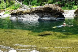
Lost Creek Lake is an excellent place for swimming and other water activities. Rivers Edge Park, Catfish Cove Day Use Area, Takelma Day Use Area, and other spots are great for swimming and launching kayaks, canoes, and paddle boards.
Boating
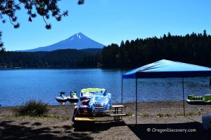
The lake is open to both motorized and non-motorized boats. With 30 miles of shore and 3,430 acres of surface, including coves and tributary arms, there is plenty of space for everyone.
You can launch your boat to the lake from 2 ramps - the Takelma boat ramp on the west bank and the Lost Creek Marina boat ramp on the east bank.
McGregor Park boat ramp sits on the Rouge River beyond the dam.

Hiking, Biking, and Horseback Riding
Lost Creek Lake and the surrounding area have many trails for hikers, bikers, and equestrians. Paths range from short, easy walks to more challenging, longer hikes.
Lost Creek Lake Trail combines multiple tracks into an extended 18.7-mile hike around the entire lake. You can choose various trails and trail sections for the desired length and difficulty level.
If you want a shorter hike, you can take a scenic 5-mile out-and-back trail from the Lewis Road Trailhead to Blue Grotto. Joseph Steward State Park has a 2.4-mile south pathway through Rummley Falls and a 3.6-mile north trail through Diamond Creek Falls.
Fishing
The Lost Creek Lake is a fantastic location for both bank and boat fishing, with an average depth of 136 feet and a maximum depth of 325 feet at the dam.
The reservoir is home to stocked rainbow and brown trout, as well as various warm-water fish, including smallmouth and largemouth bass, perch, bluegill, crappie, and brown bullhead catfish.
Bank fishing is excellent from several campgrounds and day-use areas. Boat fishing is even more productive, giving you access to the dam area and the tributary arms at the northeast and northwest corners of the lake.
Trout is stocked annually from the hatchery and easily caught from shore. Perch, bluegill, crappie, and brown bullhead catfish are best caught starting in July when the water is warmer. The most productive areas for those species are the shallower waters along the west and south shores.
You can find smallmouth bass around the dam, the rocky area around the southwest shorelines, and the coves. Largemouth bass primarily inhabit the north shore coves between Fire Glen Camp and the Lost Creek Arm.
Rockhounding
The US Army Corps of Engineers manages the lake and the surrounding area, so no rockhounding is allowed.

The Full List of Lost Lake Day-Use Areas and Campgrounds
Rivers Edge Park is a day-use area with picnic tables, a playground, and a swimming area.
Lost Creek Lake Viewpoint is a scenic spot to view the lake and the surrounding area.
Takelma Day Use Area near the dam has a paved boat ramp, dock, swimming area, and restrooms.
Four Corners Campground provides campsites, garbage disposal, tables, fire rings, and vault toilets, but no drinking water or docks.
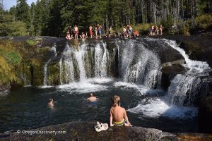
Blue Grotto is a seasonal waterfall (March through May is the best time) that cascades down a 40-foot drop over a blue-green rhyolite rock.
Fire Glen Campground has campsites, garbage disposal, tables, fire rings, and vault toilets, but no drinking water or docks.
Catfish Cove Day Use Area has a swimming area with picnic tables.
Needle Rock is a viewpoint with a steep hike.
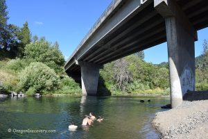
Peyton Bridge is a historic bridge with scenic views and a picnic area.
Joseph Stewart State Park has 201 campsites (151 with full water and electric hook-up), showers, flush toilets, picnic tables, fire rings, grills, and an RV dump station.
The Lost Creek Marina at Joseph Stewart State Park has a restaurant, boat rentals, and a ramp.

Lost Creek Lake Camping, Lodging & Vacation Rentals
There are three campgrounds around the lake, offering both primitive tent sites and RV spots. Camping is available at Joseph Stewart State Park, Four Corners Campground, or Fire Glen Campground. Reservations can be made online through Jackson County Parks.
For more comfortable accommodations, Shady Cove and the surrounding area offer a variety of lodging options.
Lost Creek Lake | Facts
Open: Year-round
Managed by: U.S. Army Corps of Engineers
Amenities: Restrooms, picnic sites, campsites, drinking water, boat ramps
Activities: Boating, fishing, swimming, kayaking, paddle boarding, camping, horseback riding, hiking, and nature viewing
Distance from the parking: Short
Road access: Any passenger vehicle
Day-use fees: Yes at some areas or Interagency Senior/Access/Military Pass
Elevation: 1,850 ft (564 m)
Lost Creek Lake is located:
- 36 miles northeast of Medford
- 87 miles southeast of Roseburg
- 160 miles southeast of Eugene.
Body of water: Artificial lake
Surface area: 3,430 acres
Shoreline: 30 miles (48 km)
Maximum depth: 325 ft (99 m)
Water Characteristics
Depth: Deep and shallow
Beach: Varies
Water T° (summer): Warm
Adventures Nearby


Directions to Lost Creek Lake
From Medford to Joseph Stewart County Park,
- Take OR-62/Rogue Valley Express East
- Continue on OR-62 East for 28.5 miles
- The park will be on your left.
Phone: 541-774-8183
GPS (Joseph Stewart County Park): N 42°40.673' W 122°38.194' | 42.67788, -122.63657
GPS (Peyton Bridge): N 42°41.757' W 122°36.128' | 42.69595, -122.60213
GPS (William L. Jess Dam): N 42°40.501' W 122°40.494' | 42.67502, -122.67490