

• Ritner Creek Covered Bridge is an open-air community center for locals
• This is the last covered bridge in Oregon to serve on a state highway
Ritner Creek Covered Bridge sits 2 miles south of the small community of Pedee on the border of Polk and Benton counties, a short drive from Monmouth and Corvallis.
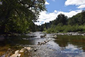
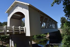
The bridge spans Ritner Creek and serves as a historical monument and a part of the small county park. This is a scenic spot where you can picnic right inside the bridge! It is also an open-air community center for gatherings, dances, hiding from the rain, and even weddings!
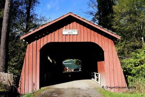
The Howe truss bridge stretches 73 feet (22 m) and features Gothic windows, a cedar shake roof, and a white paint job, like many other covered bridges in the region.

Historical Ritner Creek Covered Bridge
Both the creek and the bridge are named after Sebastian Ritner, a pioneer who settled in the area in 1845.
The bridge was built in 1927 by county contractors Hamer and Curry for a total cost of $6,964 ($125,000 in today's dollars).
The original rounded portal design was later squared in the 1960s to allow larger vehicles to pass through.
In 1974, the bridge faced demolition due to safety concerns but was saved by a community-led "Save Our Bridge" campaign initiated by school children and residents. Their efforts were successful, and the bridge was relocated in 1976 to a site adjacent to its original location near a newly built concrete bridge on Highway 223.
Ritner Covered Bridge, along with many other Oregon-covered bridges, was listed on the National Register of Historic Places in 1979.
After several repair efforts, the latest being between 2006 and 2008, it was restored to its original condition and reopened for visitors.
Interestingly, the Ritner Creek was the last covered bridge in Oregon to serve on a state highway.


Ritner Creek Covered Bridge | Facts
Architectural Bridge Design: Howe truss
Bridge access: Pedestrian
Stream: Ritner Creek
Bridge Length: 73 ft (22 m)
Built: 1927
Relocated: 1976
Repaired: 2008
Open: Year-round
Elevation: 282 ft (86 m)
Ritner Creek Bridge is located:
- 18 miles southwest of Monmouth
- 21 miles northwest of Corvallis
- 33 miles southwest of Salem.
Adventures Nearby


Directions to Ritner Creek Covered Bridge
- Take OR-194 West/Whitman Street South and follow it for 7.0 miles
- Turn left onto OR-223 South (signs for Pedee/Kings Vly) and follow it for 11.1 miles.