

• Gilkey Covered Bridge is a part of the scenic Covered Bridges Tour Route
• This is a great place to swim, fish, and rockhound
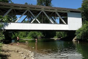
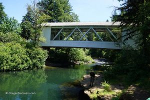
Gilkey Covered Bridge is a 120-foot-long Howe Truss bridge built in 1939 over Thomas Creek. It is a part of the scenic Covered Bridges Tour Route in the Scio-Stayton-Jordan area.
The bridge was named after the town of Gilkey, which started as a railroad station in 1880. The city itself was originally named after settlers Allen and William Gilkey.
The Gilkey station was a stop between Crabtree and Shelburn on the Southern Pacific Railroad, serving as an essential part of the delivery of railroad farming products. Until 1960, the railroad bridge was also covered.

Gilkey Bridge is an important piece of history and one of the few reminders of the past times in the area. Due to its historic significance, the bridge was added to the National Register of Historic Places in 1987.
The bridge was closed in 1997 because of damage caused by an overloaded vehicle. After all of the needed repairs were done and structural integrity and safety were ensured, the bridge was reopened in 1998.
In addition to its historic value, Gilkey Covered Bridge is an excellent spot for swimming, rockhounding, and fishing.

Swimming & Rockhounding
During the summer months, the water warms up quickly to 70-75°F. The gravel beach is nestled just below the covered bridge. The spot deep enough for swimming is located under the bridge. For those who enjoy rock collecting, the summer and early fall times are the best, when the water is low and more gravel deposits are exposed.
Fishing
The fishing season at the creek starts at the end of May and goes all the way until the end of October. Trout fishing is catch-and-release only. Salmon and steelhead angling is not allowed. Warmwater game-fish fishing for bass, crappie, bluegill, and yellow perch is open during trout season with no catch limit.

Gilkey Covered Bridge | Facts
Architectural Bridge Design: Howe truss
Bridge access: Pedestrian and vehicle
Stream: Thomas Creek
Bridge Length: 120 ft (37 m)
Built: 1939
Open: Year-round
Elevation: 260 ft (79 m)
Gilkey Bridge is located:
- 16 miles east of Albany
- 26 miles southeast of Salem
- 55 miles northeast of Eugene.
Adventures Nearby


Directions to Gilkey Covered Bridge
From I-5,
- Take exit 233 in Albany toward Sweet Home and drive 5.5 miles east on Highway 20
- Continue 2.5 miles on OR-226 to Cold Springs Road
- Turn left onto Cold Springs Road and then again left
- Follow 0.9 miles on Crabtree Drive to Gilkey Road
- Bear right onto Gilkey Road and proceed 4.2 miles to the destination.