

• Scotts Mills Falls is a first site where the best grist mill in Oregon was established
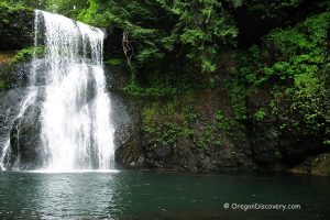
• A wide waterfall cascades through the rocky cliff into the large plunge pool
Scotts Mills County Park on the Butte Creek is known for its natural beauty and recreational opportunities. The 13 acres of lands were donated by Portland General Electric and the Haskins family.
The park’s 13 acres of land were donated by Portland General Electric and the Haskins family.
Marion County acquired and developed the property before opening it to the public in 1961.

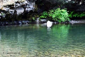
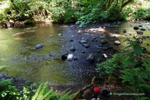
The park’s signature attraction, Scotts Mills Falls, is about 10 feet tall and 40 feet wide. The waterfall cascades over a rocky ledge below a concrete dam, where remnants of old mill sluices once diverted water from the creek.
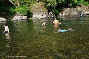
During the summer, the warm waters of Butte Creek support popular activities such as wading and crawfishing above the falls, as well as swimming and cliff jumping below them.
The park also includes picnic tables, a playground, and a ball field.

Scotts Mills Brief History
The small town of Scotts Mills on Butte Creek was the site of one of Oregon’s earliest and most successful grist mills.
Thomas McKay built a sawmill on Butte Creek in 1847.
Later, Rice Dunbar and Lewis Thomas converted the sawmill into a grist mill. Ownership changed several times before Joshua Bowman sold the mill to Robert Hall Scott in 1866.
Robert Hall Scott and his brother, Thomas Scott, who were both born in Scotland, operated the business together. The settlement became known as Scotts Mills in 1866.
In 1887, the town’s post office opened, and Thomas Scott became the first postmaster.
In 1893, Thomas Scott sold more than 2,000 acres of land to the Oregon Land Development Company. To encourage settlement, the company recruited members of the Friends Church. Although the company operated for about 12 years, it eventually went bankrupt in 1902.

Scotts Mills was officially incorporated in 1916. Before incorporation, the town already had mills, a mining operation, and a prune packing business.
A bank, a hotel, stores, a coffin factory, schools, and gas stations supported the growing community.
By the mid-20th century, economic changes led to the gradual decline of many local businesses.
On March 25, 1993, Scotts Mills was struck by a magnitude 5.6 earthquake centered about 3 miles east of town. No one was injured.
Camping and Lodging
No overnight camping in the park - day-use only.
Affordable vacation rentals for short and long term stay at Silverton.
Video
🟡 Since Portland General Electric stopped using Scotts Mills Dam in the 1950s, the structure has gradually decayed for many years. Pieces of the dam have fallen into the pool below, creating a risk of serious injury for people who jump from the dam or nearby rocks.
The Oregon Department of Fish and Wildlife proposed removing the dam structure to reduce safety hazards and allow salmon to reach their historic spawning grounds upstream. Dam removal was scheduled for September 2020.
Scotts Mills Falls | Facts
Open: May 1 - October 31
Managed by: Marion County
Amenities: Picnic tables, playground, ADA restrooms
Activities: Swimming, wading, hiking, fishing, and picnicking
Distance from the parking: Short
Road access: Any passenger vehicle
Day-use fees: None
Restrictions: Smoking and alcohol are prohibited
Dogs: Must be on a leash
Elevation: 440 ft (122 m)
Scotts Mills Park is located:
- 8 miles east of Silverton
- 22 miles northeast of Salem
- 40 miles south of Portland.
Swimming hole rating: 3 out of 5
Body of Water: Creek, waterfall
Water quality: Transparent
Current: Light to moderate
Depth: Deep and shallow
Beach: Bedrock and river rocks
Water T° (summer): Cool to warm
Adventures Nearby


Directions to Scotts Mills Falls
From Silverton,
- Take Highway OR-213 and drive 4.8 miles to Mt Angel Scotts Mills Road
- Turn right onto Mt Angel Scotts Mills Road and follow 2.7 miles to Crooked Finger Road
- Turn right onto Crooked Finger Road and continue 0.2 miles to the destination.