• Sixes River is popular among recreational gold prospectors
• Most of the river banks are private besides a few public access
![]()
![]()
![]()
![]()
The scenic Sixes River originates in the Rogue-River Siskiyou National Forest. It flows more than 30 miles west through dense coastal forest before entering the Pacific Ocean about five miles north of Port Orford at Cape Blanco.
Roughly two-thirds of the watershed is privately owned, including the lower 16 miles of the river. Public access is available at the river mouth within Cape Blanco State Park and farther upstream at the Edison Creek Campground and Day-Use Area.
Much of the upper river lies under mining claims, and many access roads are gated by private logging companies. However, several miles managed by the U.S. Forest Service remain open to the public. This stretch offers a peaceful setting for enjoying the river, swimming, and other outdoor activities.
The origin of the river's name is uncertain, with several theories recorded. Some sources suggest it honors a leader of a local Indigenous clan. Others trace the name to the Chinook language, where it is said to mean "friend." Another interpretation links it to a Kwatami tribal term meaning "people by the far north country."

Sixes River Gold Panning & Rockhounding
The river rises in the Klamath Mountains and, along with the Elk River, flows through the Grassy Knob and Copper Salmon Wildernesses.
In the mid-1800s, rich gold placer deposits were discovered on the Sixes River, drawing early settlers seeking fortune. While few became wealthy, many earned enough for a good living.
The boom led to the establishment of the town of Summersville, featuring a general store, a tavern, twelve houses, and a small logging business. However, with the Great Depression and the depletion of gold deposits, the town was eventually abandoned, leaving no ruins remain today.
Although large-scale mining has ended, small amounts of gold can still be found in the river, making it popular for recreational prospecting. Gold panning and rockhounding are generally allowed without permits on most Bureau of Land Management and U.S. Forest Service lands; however, care should be taken to avoid trespassing on private property.
Mining activities are restricted from fall to mid-summer due to salmon spawning. Always check the current regulations and mining dates by contacting the Oregon Department of Fish and Wildlife.
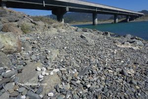
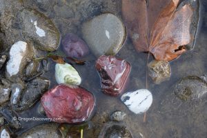
The riverbanks and riverbed are composed of gravel and rocks in various sizes and colors, making it a haven for rock collectors. You can find white quartz, agate, petrified wood, and green, yellow, and red brecciated jasper.
The best spots for rock collecting are at the mouth of the Sixes River in the Cape Blanco State Park. Another prime location for prospecting and rockhounding, offering easy access and camping is Sixes River Recreation Site.
Sixes River Fishing
Sixes River is known for fall runs of wild Chinook and coho salmon, as well as winter steelhead and resident cutthroat trout. The fishing is restricted to the lower 16 miles of the river, with limited bank access in many areas. Always check current seasons, regulations, and closures before you go.
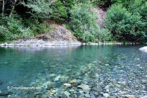
Sixes River Swimming & Other Water Activities
The Sixes River is a popular destination for summer water activities. Its clear, relatively calm waters make the river ideal for refreshing swimming and wading. The water remains cool even in midsummer, typically around 65°F in August.
During summer, gentle flows also allow for boating and kayaking in select sections.
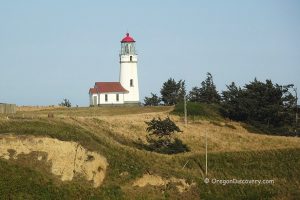
Cape Blanco Lighthouse & State Park
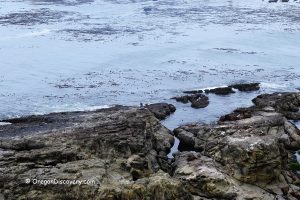
 Cape Blanco State Park provides access to the Sixes River at its mouth as well as to the ocean beaches south and north of Cape Blanco. The park boasts over 400 years of recorded history and scenic beauty of the coastal nature.
There are over eight miles of hiking trails, a 150-acre horse riding area, a campground, an early Irish settler's house, and Cape Blanco Lighthouse which is the oldest, windiest, and westernmost light station in Oregon.
Cape Blanco Lighthouse - The Oldest & Most Westerly in Oregon

Edison Creek Campground & Recreation Area
Edison Creek Campground and Recreation Area sits at the creek entering the Sixes River. This area has 27 campsites and 5 reservable group sites each with enough space for up to 25 people. The campground has picnic tables, fire rings, accessible toilets, and drinking water.
Swimming, fishing, picnicking, and boating are popular pasttimes here. The campground has a boat ramp.

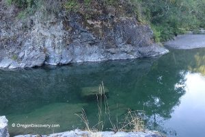
Elephant Rock Creek Bridge
This scenic and secluded destination at the junction of Elephant Rock Creek and the Sixes is a perfect roadside swimming hole. Public land begins at the eastern side of the bridge over the Elephant Rock Creek. Park your car and find a short trail to the river.
This truly unique site features beautiful rock formations and clear emerald-green water. If your intention is not just to wade and enjoy the river, you can swim in a deep swimming hole at the huge rock in the middle of the river.
Sixes River Recreation Site
Sixes River Recreation Site is a small campground managed by the Bureau of Land Management. The site features 19 campsites, each equipped with picnic tables and fire rings, ideal for outdoor meals and campfires. Drinking water is available, and there are vault toilets.
In addition to camping and picnicking, this spot provides opportunities for swimming, fishing, and gold panning.
Warning! Be mindful of poison oak and wildlife, including cougars, bobcats, and bears, which may occasionally be encountered in the area.

Adventures Nearby