

• Twin Springs Rockhounding Area is a remote haven for rock collectors
Twin Springs is a premier rockhounding destination in Southeastern Oregon, located west of Owyhee Reservoir, approximately 39 miles southeast of Nyssa and 35 miles south of Vale.
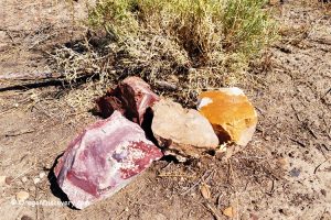
This rugged, sagebrush-covered landscape is a haven for rock collectors, offering an impressive array of agate, jasper, petrified wood, chalcedony, calcite, and, on occasion, geodes. While minerals are abundant throughout the area, some locations yield higher concentrations than others.

Twin Springs Rockhounding
Agates of various sizes can be found here, typically in shades of clear, white, blue, or gray. Many display distinctive features such as waterlines, mossy patterns, or intricate botryoidal and crystalline cavities.
Jasper is equally plentiful, with hues ranging from blue and green to gray and brown. These stones vary in size, from small, tumbled-ready pieces to larger, solid chunks ideal for cutting and polishing.
Surface collecting in the area can yield a variety of "float" materials scattered across sagebrush flats, old dumps, dry washes, and hillsides. Start by surface collecting to assess whether a spot appears promising.
We explored three different locations, with the last one proving especially rich in material. To navigate these areas, a rugged 4WD, high-clearance vehicle is highly recommended.
Be mindful of any claim markers to avoid trespassing, and always exercise caution when exploring these remote areas.

Twin Springs Rockhounding Area: Camping, Lodging, and Vacation Rentals
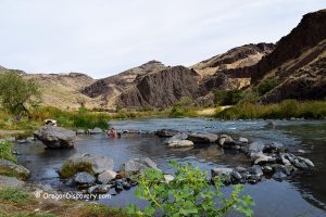
Camping is permitted throughout BLM land, with the nearest campground, Twin Springs, located conveniently nearby. This campground makes an excellent base for exploring other rockhounding sites in the area, including Haystack Butte and Negro Rocks.
For those seeking lodging, accommodations are available 50 miles east in Homedale, Idaho, and 50 miles northeast in Ontario, Oregon.
Affordable vacation rentals for short and long term stay in Homedale, ID
Affordable vacation rentals for short and long term stay in Ontario, OR

Know Before You Go
The Twin Springs area is a remote desert destination that requires careful preparation. Here are some essential tips for a safe and rewarding rockhounding experience.
- No services are available within 20-30 miles, so ensure your vehicle is fully fueled and stocked with necessities.
- It's best to avoid visiting during rainy weather, as the roads may become impassable.
- A high-clearance 4WD vehicle is advised, along with spare tires, sunscreen, and plenty of water.
- Since cell service is limited, inform someone of your plans or bring a satellite communication device.
Twin Springs Rockhounding Area | Facts
Best time: May through October
Managed by: Bureau of Land Management (BLM)
Rocks & Minerals: Agate, jasper, petrified wood, chalcedony, calcite, and geodes
Tools: Shovel, geology pick, hammer, and chisel
Amenities: Vault toilet, hand-pump water for washing only, picnic table, and fire ring at Twin Springs Campground
Activities: Rockhounding, camping, and wildlife observing
Distance from the parking: Vary
Road access: A high-clearance 4WD vehicle
Day-use fees: None
Elevation: 2,800-3,600 ft (850-1,100 m)
Twin Springs Rockhounding Area is located:
- 39 miles southeast of Nyssa
- 260 miles east of Bend
- 420 miles southeast of Portland.
Adventures Nearby


Driving Directions to Twin Springs Rockhounding Sites
The road from Vale (Highway 20/26) is longer and rougher. We recommend using Nyssa as the start point.
From Nyssa,
- Take Highway OR 201 and drive for 8 miles to Owyhee Avenue
- Turn right onto Owyhee Avenue and head 6 miles east to Mitchel Butte Road
- Turn left onto Mitchel Butte Road and continue 0.5 miles to a fork; at the fork, bear right
- Drive 4.9 miles to another fork and take the right road, and after 0.3 miles keep right
- Continue 0.9 miles to the next fork and go straight
- Drive 2.4 miles to Twin Springs Road
- Turn left onto Twin Springs Road and follow for about 12.8 miles to the campground
- From the campground continue straight on Dry Creek Road for 1 mile to Site 1 and for 2.8 miles to Site 2.
GPS (Campground): N 43°37.032' W 117°25.075' | 43.6172, -117.4179
GPS (Site 1): N 43°36.112' W 117°24.648' | 43.6019, -117.4108
GPS (Site 2): N 43°34.809' W 117°24.306' | 43.5801, -117.405