

• Graveyard Point is famous for its unique plume agates
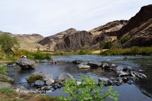
Tucked away in the rugged landscapes of easternmost Oregon, Graveyard Point in Owyhee Canyon beckons with its unique blend of history, mystery, and, of course, rocks!
The name comes from the small cemetery in the town of Homedale in Idaho, with the Graveyard Point stone monument standing not far from the route to the collecting site.
Graveyard Point Rockhounding
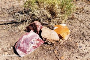
This area is well-known for its extensive deposits of seam agate, spread across hundreds of acres of high desert and hills. The agate veins, formed in basalt cracks, can reach up to 18 inches thick and extend as long as 40 feet. These cracks are often filled with clear chalcedony, adorned with plume-like inclusions and, occasionally, black dendrites. While the chalcedony background is typically clear or light blue, you might also discover specimens in light amber, reddish, or dark gray hues.


Most of the area is managed by the Bureau of Land Management (BLM) and open for rock collecting, but it’s important to note that many mining claims exist. Be sure to watch for posted signs marked by PVC pipes or wooden posts, and always adhere to BLM rules and regulations.
Despite its popularity over the years, Graveyard Point still offers rockhounds the opportunity to find exceptional specimens. While there are plenty of agate floats on the surface, larger and higher-quality pieces often require a bit more effort. To uncover these treasures, look for a vein, grab your geological pick, and prepare to do some mining.
Check areas where other rockhounds have been digging, or explore hillsides and veins exposed by closed mine operations. In addition to plume agates, collectors can also find other varieties of agate, quartz, petrified wood, limb casts, picture jasper, and jasper.

Graveyard Point: Camping and Lodging
Primitive camping is allowed throughout BLM land. If you're looking for accommodations near Graveyard Point, you may need to consider options in nearby towns or cities since Graveyard Point itself is a remote and primarily natural area with limited lodging options. Here are some towns and cities nearby where you can find accommodations:
Affordable vacation rentals for short and long term stay in Homedale, Idaho
Affordable vacation rentals for short and long term stay in Ontario, Oregon
Graveyard Point Rockhounding Area | Facts
Best time: May through October
Managed by: Bureau of Land Management (BLM)
Rocks & Minerals: Plume agate, other varieties of agates, quartz, petrified wood, limb cast, picture jasper, and jasper
Tools: Shovel, geology pick, hammer, and chisel
Activities: Rockhounding, camping, and wildlife observing
Distance from the parking: Vary
Road access: A high-clearance 4WD vehicle is suggested
Day-use fees: None
Elevation: 2,600 - 2,800 ft (792 - 853 m)
Graveyard Point is located:
- 8 miles southwest of Homedale, ID
- 48 miles west of Boise, ID
- 282 miles east of Bend
- 400 miles southeast of Portland.
Adventure Nearby


Directions to Graveyard Point
Do not rely on Google Map Driving Directions. To get to the public collection area you should drive through Homedale in Idaho.
From Bend in Oregon,
- Take Highway 20 and travel 242 miles east to Glenn Street in Vale
- Turn right onto Glenn Street which becomes Lytle Blvd and follow it for 12.5 miles to Grand Avenue
- Turn left onto Grand Avenue and go 2.9 miles east to Fairview Drive
- Turn right onto Fairview Drive which becomes OR-201 or Succor Creek Highway and travel 17.3 miles to Highway 19 in Idaho
- Continue 5.2 miles east to Highway 95 in Homedale and continue your trip according to the directions listed below.
From Homedale in Idaho,
- Take Highway 95 and follow it 3 miles south to Graveyard Point Road
- Turn right onto Graveyard Point Road and follow for about 4 miles west to Nielsen Lane which becomes Sage Road; for the stone monument, continue 0.5 miles on Graveyard Point Road straight to the monument on the right
- Turn left onto Nielsen Lane (Sage Road) and continue 0.9 miles to a bridge across South Canal
- Cross the bridge; two right and left roads are private drives, so choose the second left dirt road and continue for 2 miles on the main track.
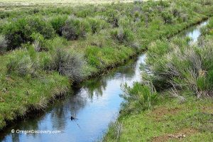
From this point, you can go straight and then northwest along Succor Creek or on the left (south). Explore the desert along the road for floats and old diggings and also check hills and ridges.
There is useful information here but the thing that stuck out was where the directions listed has this west of Bend and Portland.
Fixed, thank you.
Are there any affordable rock shops that will ship agates from here?thank, Joe