

• Haystack Butte is a remote area known for its distinctive colorful jasper
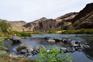
Haystack Butte, also known as Haystack Rock, is a remote and rugged high desert destination located within the boundaries of the Owyhee region, approximately 24 miles southeast of Nyssa and 30 miles south of Vale. The butte rises from the sagebrush-covered landscape, offering stunning desert views and abundant opportunities for rock and mineral collecting.
Part of the vast Owyhee Canyonlands, Haystack Butte was shaped over millions of years by volcanic activity, erosion, and changing waterways. The area features dramatic canyons, rolling hills, and ancient volcanic formations.
This site is well-known among rockhounds for its colorful jasper, mossy agate, petrified wood, chalcedony, and occasional common opals.
To the east and south of Haystack Butte, rockhounds can explore additional collecting sites, including Twin Springs, Negro Rock, and Succor Creek.

Haystack Butte Rockhounding
The Haystack Butte area produces a wide variety of rocks and minerals, including jasper, agate, petrified wood, chalcedony, and common opal. Jasper in this area appears in vibrant hues, such as bright red, green, and yellow, with some patterns resembling brecciated textures and others resembling jellybeans. It polishes well, making it ideal for crafting beautiful cabochons.
Agate typically comes in shades of clear, white, or gray and may feature mossy or botryoidal patterns.
There are a lot of materials on the surface. Look for floats amid the sagebrush, dumps, dry washes, and hillsides. Surface collecting is a good way to start. Be sure to bring a rock hammer, shovel, and geology pick.
Exercise caution and respect any claim markers encountered to avoid trespassing.

Haystack Butte Rockhoundin Area: Camping, Lodging, and Vacation Rentals
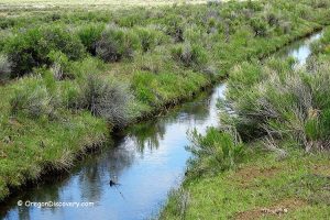
Camping is allowed throughout BLM land. The closest campground, Twin Springs is located 15 miles away. This campground is an excellent base for exploring other rock collecting sites in the area such as Twin Springs and Negro Rocks.
Lodging is available 50 miles east in Homedale, Idaho or 50 miles northeast in Ontario, Oregon.
Affordable vacation rentals for short and long term stay in Homedale, ID
Affordable vacation rentals for short and long term stay in Ontario, OR

Know Before You Go
The Haystack Butte area is a remote desert destination that requires careful preparation. Familiarize yourself with desert safety practices for a safe and rewarding rockhounding trip.
- There are no services within 20-30 miles, so make sure your vehicle is fueled and stocked with essentials.
- Avoid visiting during rainy conditions, as the roads can become impassable.
- A high-clearance 4WD vehicle is recommended, and bring spare tires, sunscreen, and plenty of water.
- With limited cell service, notify someone of your plans or carry a satellite device.
Haystack Butte Rockhounding Area | Facts
Best time: May through October
Managed by: Bureau of Land Management (BLM)
Rocks & Minerals: Jasper, agate, petrified wood, chalcedony, and common opal
Tools: Shovel, geology pick, hammer, and chisel
Amenities: None
Activities: Rockhounding, camping, and wildlife observing
Distance from the parking: Vary
Road access: A high-clearance 4WD vehicle
Day-use fees: None
Elevation: 2,700 ft (820 m)
Haystack Butte is located:
- 24 miles southeast of Nyssa
- 270 miles east of Bend
- 400 miles southeast of Portland.
Adventures Nearby


Driving Directions to Haystack Butte Rockhounding Area
The road from Vale (Highway 20/26) is longer and bumpier, so we recommend starting from Nyssa instead for a smoother drive.
From Nyssa,
- Take Highway OR 201 and drive for 8 miles to Owyhee Avenue
- Turn right onto Owyhee Avenue and head 6 miles east to Mitchel Butte Road
- Turn left onto Mitchel Butte Road and continue 0.5 miles to a fork; at the fork, bear right
- Drive 4.9 miles to another fork and take the left road
- Continue 2.5 miles to the next fork
- Bear left onto Haystack Road and follow for approximately 1.5 miles.
Check any promising dry washes and gullies on your way.
GPS coordinates were taking along the road at one of a dry wash where we found great specimens during our recent trip.