Applegate Lake Day-Use Areas & & Key Spots
Applegate Dam, Da-Ku-Be-Te-De - Swayne Viewpoint, and Trailhead
 Located on the northern edge of the lake near Applegate Dam, this site offers sweeping views of the dam, reservoir, and surrounding forested hills.
The Da-Ku-Be-Te-De Trail is a moderate 8.5-mile loop that follows the northern shoreline to Watkins Campground.
Da-Ku-Be-Te-De - Swayne Viewpoint - The Best Place to See the Applegate Lake
Hart-tish Park and Day-Use Area
 Hart-Tish Park is a popular spot for camping, picnicking, and lake access.
It serves as an excellent base for exploring the area and offers swimming, boating, fishing, and access to trails. Collings Mountain Trailhead begins here, and both the Da-Ku-Be-Te-De Trail and Grouse Loop Trail are nearby.
Hart-Tish Park Day-Use & Campground - Scenic Southern Oregon Escape
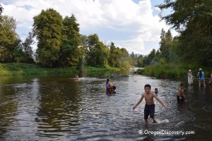
Carberry Swimming Area
 This peaceful swimming area features a sandy beach, large shoreline rocks, and scenic views.
Carberry Creek flows into the reservoir here, forming a small seasonal waterfall.
Carberry Swim Area and Campground - Outdoor Fun at Applegate Lake