

• McDowell Creek Falls Park is a hidden gem with dramatic landscape
• Popular for its beautiful Majestic and Royal Terrace waterfalls
McDowell Creek Falls County Park is a hidden gem in canyons of Fall and McDowell Creeks on the western foothills of the Cascade Mountains. The 110-acre park with dramatic landscape offers beautiful views of two large and two small waterfalls, fishing, hiking, and picnicking opportunities.
While hiking along a popular year-round trail, you can see all waterfalls. This one to eight-mile loop trail runs the length of the park through the scenic mossy rainforest along McDowell Creek and crosses Fall Creek. The trail can be accessed from upper, middle, or lower parking areas.
If you prefer short hikes to waterfalls, you can park your car at any parking lot and start exploring waterfalls nearby.
Majestic Falls & Crystall Falls
Majestic Falls and Crystall Falls are located near the upper parking area.
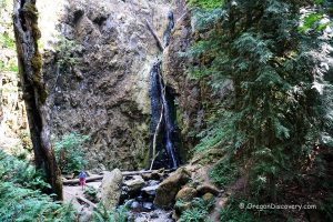
Majestic Falls is the most beautiful waterfall of McDowell Creek Park. The established system of staircases with 69 steps allows exploring cascading waterfall from different viewpoints. You will start your journey from the wide platform offering vistas of the water streams leaping down the 39-foot cliff. To see Majestic Falls from the bottom, continue down the stairs to a lower viewing platform and a wooden bridge.
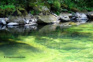
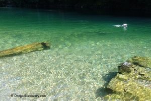
For the 14-foot Crystal Falls and Pool, cross the wooden bridge and hike 0.2 miles downstream where you will find a steep trail to the creek and better waterfall observation.


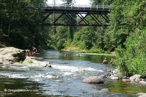
Royal Terrace Falls & Lower McDowell Creek Falls
Royal Terrace Falls and Lower McDowell Creek Falls are easily accessible from the middle or lower parking areas.
If you start from the middle lot, you need to cross a wooden bridge across McDowell Creek and then hike for about 0.2 miles to the wooden bridge across Falls Creek. From the lower parking lot, cross the bridge near Lower McDowell Falls and walk 0.3 miles upstream to the Falls Creek bridge where you can enjoy an excellent view of the double 119-foot Royal Terrace Falls.
Steep stone stairs with 123 steps on the west side of the bridge takes you up to the middle waterfall terrace and a small viewing platform. Be aware that the trail is very steep, tends to be muddy after the rains and can be challenging for unprepared hikers. Also, a floor of the stone terrace between upper and lower drops is slippery. After the middle terrace, climb up to the wooden bridge that crosses Fall Creek just before the rushing water slides and cascades down the rock face.
The top of Lower McDowell Falls is visible as you cross the wooden bridge near the lower parking area. To see Lower McDowell Falls from its base, walk 90 yards through picnic areas and then down to the creek.


McDowell Creek Falls | Facts
Open: Year-round
Managed by: Linn County Park
Amenities: Picnic areas, restrooms
Distance from the parking: Vary
Road access: Any passenger vehicle
Day-use fees: Free
Activities: Hiking, nature viewing, fishing, wading, picnicking
Dogs: Must be on a leash
Elevation: 700-1,000 ft (274-319 m)
McDowell Creek Falls County Park is located:
- 9 miles northeast of Sweet Home
- 47 miles southeast of Salem
- 50 miles northeast of Eugene
- 90 miles south of Portland.
Majestic Falls
Total height: 39 feet (12 m)
Stream: McDowell Creek
Primary form: Curtain
Crystal Falls
Total height: 14 feet (4 m)
Stream: McDowell Creek
Primary form: Plunging Punchbowl
Royal Terrace Falls
Total height: 119 feet (36 m)
Stream: Falls Creek
Primary form: Tiered Horsetails
Lower McDowell Falls
Total height: 20 feet (6 m)
Stream: McDowell Creek
Primary form: Tiered Plunges
Adventures Nearby
Directions to McDowell Creek Falls
From I-5 in Albany,
- Take exit 228 for Highway OR-34 toward Lebanon
- Drive 5.4 miles east on Highway OR-34 to Denny School Road
- Take Denny School Road on the right and go 1.5 miles south and then 2.1 miles east on Airport Drive to Highway US-20
- Turn right onto Highway US-20 and go 5.3 miles to Old Santiam Highway
- Turn left and then right onto Fairview Road
- Continue 0.9 miles on Fairview Road to McDowell Creek Road
- Turn left onto McDowell Creek Road and go 8.2 miles to the destination.
Phone: 541-967-3917
GPS (Upper Parking Area): N 44°28.064', W 122°40.446' | 44.4677, -122.6741
GPS (Lower Parking Area): N 44°27.859', W 122°40.930' | 44.4643, -122.68217
When was McDowell Creek Park built?