• Trask River features numerous swimming holes
• The river is well-known for excellent fishing opportunities
The scenic coastal Trask River flows over 50 miles from the Northern Oregon Coast Range. Like the other five rivers including the Wilson, the Kilchis, the Miami, and the Tillamook, the Trask empties into the Tillamook Bay.
The 18-mile Trask River is formed by North and South Forks joining together near Trask River County Park in the Tillamook State Forest.
The river is well-known not only as an excellent place to catch Chinook salmon or steelhead but also it features numerous swimming holes including secret ones.

Dam Hole
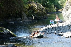
Though this place is quite popular among anglers, in the summertime the crystal-clear water of this coastal river attracts those who enjoy spending hot days splashing in cool creek water.
The 90-foot beach is composed of coarse sand and pebble. The opposite bank is framed with rock walls with a tiny waterfall dropping into the river. There are underwater ledges in the middle of the river. Deep areas that are suitable for swimming are found at the mossy big rock on the left and downstream on the right of underwater ledges.
There are shallows near the beach. No restroom or garbage service is available. Pack out all your trash.
Directions
From US-101 in Tillamook, take Highway OR-6 and travel 2.3 miles east to Cedar Butte Road. Turn right onto Olsen/Trask River Road and continue 1.8 miles. Turn left (do not cross the bridge) and follow 5.4 miles to a turnout on the left.
The trail from the turnout runs down to the river.

North Fork Bend
A great destination on the North Fork of the Trask River is located 0.5 miles away from Trask River County Park. Park your car at a turnout on the right or a huge hill on the left side and find a trail leading down to the river.
This is a secluded site with the river running through a maze of rocks into a narrow channel creating a small waterfall. The waterfall cascades down to a beautiful green pool surrounded by gorgeous rock formations. The water is transparent to the bottom and, typically, warms up during the summer heats to 65F at the end of July.
There are shallows downstream.

Directions
From Dam Hole, follow 4.6 miles east on Trask River Road to North Fork Road. Turn left onto North Fork Road and continue 0.4 miles to the destination.

Adventures Nearby