

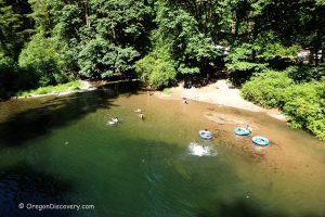
• One of the excellent swimming holes on Fall Creek near Big Pool Campground
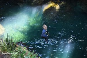
• The deep emerald pool with underwater ledges and flat rock formations
Located 0.4 miles east of Big Pool Campground, this deep emerald pool in crystal-clear Fall Creek offers a perfect spot to cool off on a hot summer day. Underwater ledges and flat rock formations create natural platforms for relaxing, while the opposite bank features river boulders and rocks.
This area has no amenities. Please respect the site and pack out all trash.
The 13.7-mile Fall Creek National Recreation Trail winds through the scenic Willamette National Forest, offering excellent spots for picnicking, fishing, swimming, and enjoying the view.
Big Pool Campground
Big Pool Campground is a small group site camp with space for up to six people, two tents, and two vehicles.
Bedrock Campground, located three miles east, offers 22 campsites: six for tents only, one accessible site, and 15 RV sites (max length 30 feet).
Reservation for both campgrounds is recommended in advance at www.recreation.gov.
Fall Creek – Big Pool | Facts
Open: May - September from sunrise to sunset
Managed by: US Forest Service
Amenities: None
Activities: Swimming, hiking, fishing
Distance from the parking: Short
Road access: Any passenger vehicle
Day-use fees: None
Elevation: 1,000 ft (305 m)
Big Pool Swimming at Fall Creek:
- 33 miles east of Eugene
- 94 miles southeast of Salem
- 143 miles southeast of Portland.
Swimming hole rating: 4 out of 5
Body of Water: River
Water quality: Transparent
Current: Light to moderate
Depth: Deep and shallow
Beach: Bedrock and rock formation
Water T° (summer): Cool
Adventures Nearby


Directions to Big Pool
From I-5,
- Take Exit 194 A in Eugene for Highway 126 East
- Follow on Highway 126 for 6.8 miles to Bob Straub Parkway
- Travel 7.6 miles straight onto Bob Straub Parkway, then Highway 222 South and Jasper/Jasper Lowell Roads to Place Road
- Turn left onto Place Road/Big Fall Creek Road and continue 4.5 miles
- Bear left after passing Winberry Creek Road and follow for about 11.4 miles to the destination on the right.