

Negro Rock Rockhounding Site is one of a few rock-collecting destinations west of Owyhee Reservoir, approximately 30 miles southeast of Nyssa and 26 miles south of Vale.
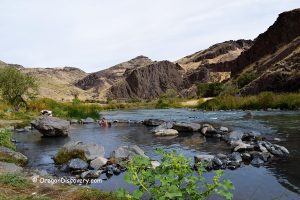
This remote, expansive high desert area is covered by sagebrush and surrounded by interestingly shaped hills with rocky heads on the tops. One of these hills serves as a prominent landmark, indicating the area that should be searched. The hillsides near this landmark are known for the excellent quality of petrified wood. Other minerals can also be found.
A 4WD, high-clearance vehicle is highly recommended to navigate this site.
Twin Springs and Haystack Butte are other great rock-collecting sites nearby, and if you are in the area, it makes sense to visit all of them.

Negro Rock Rockhounding
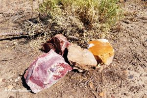
The area around Negro Rock boasts high-quality petrified wood with excellent cellular replacement. The wood colors are typically beige, orange, brown, gray, and black. Other minerals, including common opal, agate, jasper, and milky quartz, are also present. Common opal is primarily brown. Agate can be clear, yellowish, and reddish. Some have a water line. Jasper is typically green, brown, and gray.
Once you arrive at the site, hike around the hill and look for floats through dry washes, sagebrush, and hillsides.
If you are lucky, digging the ground can yield larger pieces of wood, but that isn't always the case. During our last trip, we found no signs of previous digging, but we did discover some materials hidden among sagebrush and dry washes.


Negro Rock Rockhounding Area: Camping, Lodging, and Vacation Rentals
Camping is allowed throughout BLM land. The closest campground, Twin Springs is located 15 miles away. This campground is an excellent base for exploring other rock collecting sites in the area such as Twin Springs and Negro Rocks.
Lodging is available 50 miles east in Homedale, Idaho or 50 miles northeast in Ontario, Oregon.
Affordable vacation rentals for short and long term stay in Homedale, ID
Affordable vacation rentals for short and long term stay in Ontario, OR
- No Services: No gas, water, or cell reception for 20-30 miles. Fuel up and pack essentials.
- Wildlife: Watch for rattlesnakes. Stay alert.
- Weather: Avoid when roads are wet or during rain. Conditions can be dangerous.
- Vehicle: 4WD with high clearance is needed, plus off-road experience.
- Supplies: Bring spare tires, sunscreen, and water. Inform someone of your plans or carry satellite communication.
- Safety: Know desert safety tips for this rugged area.
Negro Rock Rockhounding Site | Facts
Best time: May through October
Managed by: Bureau of Land Management (BLM)
Rocks & Minerals: Petrified wood, common opal, agate, quartz, and jasper
Tools: Shovel, geology pick
Amenities: None
Activities: Rockhounding, camping, and wildlife observing
Distance from the parking: Vary
Road access: A high-clearance 4WD vehicle
Day-use fees: None
Elevation: 3,100 ft (945 m)
Negro Rock is located:
- 24 miles southeast of Nyssa
- 250 miles east of Bend
- 410 miles southeast of Portland.
Adventures Nearby


Driving Directions to Negro Rock Rockhounding Site
The road from Vale via Highway 20/26 is a longer and rougher route. We recommend starting from Nyssa for a smoother drive.
From Nyssa,
- Take Highway OR 201 for 8 miles to Owyhee Avenue
- Turn right onto Owyhee Avenue and drive 6 miles east to Mitchel Butte Road
- Turn left onto Mitchel Butte Road and follow 0.5 miles to a fork; bear right at the fork
- Continue 4.9 miles to another fork and take the right road, and after 0.3 miles keep right
- Drive 0.9 miles to the next fork and go straight
- Continue 2.4 miles to Twin Springs Road
- Turn left onto Twin Springs Road and travel 6.8 miles to the destination on the right.