

• Wagon Wheel Park is a great summer destination at the Molalla River
• Features a large swimming area with deeps and shallows
![]()
![]()
![]()
Wagon Wheel Park is a scenic county park along the banks of the Molalla River, just off Highway 213 in the small community of Mulino, about 16 miles from Woodburn.
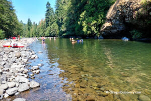
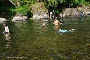
The large swimming hole upstream of the bridge, measuring approximately 250 feet long and 150 feet wide, is a popular summer destination thanks to its convenient location within easy driving distance of Salem and Portland.
The river is shallow along the banks and gradually becomes deeper toward the middle of the channel. A large rock ledge on the opposite bank overlooks the deepest section and is often used as a jumping spot.
The swimming area becomes shallower toward the edges. During the summer months, the current is usually gentle, but swimmers should remain aware of strong undercurrents. The riverbed consists of sand mixed with rocks and large boulders.

This is a popular swimming destination, and the parking area often fills up on warm summer days.
Camping, open fires, shooting, and alcohol are prohibited.
⚠️ Strong undercurrents and steep riverbanks can be dangerous. Several drownings have occurred at this site. Always supervise children closely, use caution near the water, and enter the river only when conditions are safe.

Wagon Wheel Park | Facts
Open: Seasonally from 6 am to 6 pm
Managed by: Clackamas County
Amenities: Vault toilet
Activities: Swimming, fishing, hiking
Distance from the parking: Short
Road access: Any passenger vehicle
Day-use fees: None
Elevation: 400 ft (122 m)
Wagon Wheel Park is located:
4 miles north of Molalla
34 miles northeast of Salem
30 miles southeast of Portland.
Adventures Nearby


Directions to Wagon Wheel Park
From I-5,
- Take exit-271 and then turn left onto OR-214 toward Woodburn
- Head 14 miles east via OR-214, then OR-211 to OR-213
- Turn left onto OR-213 and continue 3.6 miles north to the destination on the right.
The hike from the parking area to the river edge is short.